IMAGES TAKEN NEAR TO
West Hill Avenue, EPSOM, KT19 8JX
Introduction
This page details the photographs taken nearby to West Hill Avenue, KT19 8JX by members of the Geograph project.
The Geograph project started in 2005 with the aim of publishing, organising and preserving representative images for every square kilometre of Great Britain, Ireland and the Isle of Man.

There are currently over 7.5m images from over14,400 individuals and you can help contribute to the project by visiting https://www.geograph.org.uk
Image Map
Images are licensed for reuse under creativecommons.org/licenses/by-sa/2.0
Notes
- Clicking on the map will re-center to the selected point.
- The higher the marker number, the further away the image location is from the centre of the postcode.
Image Listing (5 Images Found)
Images are licensed for reuse under creativecommons.org/licenses/by-sa/2.0
Image
Details
Distance
1
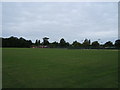
Court Recreation Ground, Epsom
Taken from approx TQ 206 613.
Image: © Roger Miller
Taken: 27 Aug 2005
0.18 miles
2
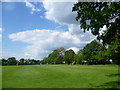
Court Recreation Ground
Court Recreation Ground is just north of the centre of Epsom, beyond the station.
Image: © Marathon
Taken: 14 May 2014
0.20 miles
3
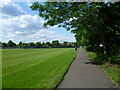
Court Recreation Ground
Court Recreation Ground is just north of the centre of Epsom, beyond the station. This path runs along the eastern edge.
Image: © Marathon
Taken: 14 May 2014
0.21 miles
4
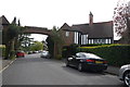
Arch on Meadway
This arch is one of the entrances to the 1930's housing estate known as the Chase Estate after the Reverend Chase who used to own the farm here Epsom Court. He died in 1903.
Image: © Nigel Mykura
Taken: 17 Apr 2015
0.22 miles
5
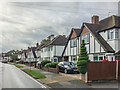
Hazon Way
1930s housing, first marked in outline on the 1944 6 inch map.
Image: © Ian Capper
Taken: 4 Oct 2019
0.23 miles