IMAGES TAKEN NEAR TO
Lindsay Close, EPSOM, KT19 8JJ
Introduction
This page details the photographs taken nearby to Lindsay Close, KT19 8JJ by members of the Geograph project.
The Geograph project started in 2005 with the aim of publishing, organising and preserving representative images for every square kilometre of Great Britain, Ireland and the Isle of Man.

There are currently over 7.5m images from over14,400 individuals and you can help contribute to the project by visiting https://www.geograph.org.uk
Image Map (Loading...)


Getting Data...Please wait
Leaflet Map data © OpenStreetMap
Images are licensed for reuse under creativecommons.org/licenses/by-sa/2.0
Notes
- Clicking on the map will re-center to the selected point.
- The higher the marker number, the further away the image location is from the centre of the postcode.
Image Listing (16 Images Found)
Images are licensed for reuse under creativecommons.org/licenses/by-sa/2.0
Image
Details
Distance
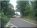
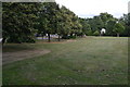
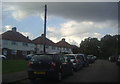
2
Houses on Meadway
Meadway runs north off West Hill the B280 just west of Epsom. In the foreground is the grass of Clayhill Green
Image: © Nigel Mykura
Taken: 17 Apr 2015
0.13 miles
3
Footpath access into Epsom Town Centre from West Hill
Image: © peter lloyd
Taken: 19 Nov 2005
0.13 miles
6
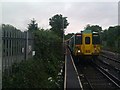
Class 455 in the Down Siding
A Class 455 unit waits briefly in the Down Siding before returning to the platform with a Victoria via Hackbridge service.
Image: © Tony Rispoli
Taken: 17 Jun 2011
0.17 miles
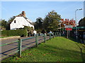
7
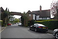
Arch on Meadway
This arch is one of the entrances to the 1930's housing estate known as the Chase Estate after the Reverend Chase who used to own the farm here Epsom Court. He died in 1903.
Image: © Nigel Mykura
Taken: 17 Apr 2015
0.18 miles
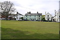
8
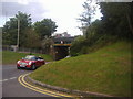
West Hill at the junction of Wheelers Lane
Image: © David Howard
Taken: 20 Aug 2012
0.19 miles
9
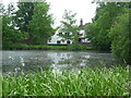
Stamford Green Pond on Epsom Common
Epsom Common was once the 'waste' of the Manor of Epsom. This meant that it was deemed unfit for cultivation and was only used for grazing by local people. It was purchased by Epsom and Ewell Borough Council in 1936 for £4,000. Prior to the Second World War it was largely open grassland and remnant heath, grazed by cattle and pigs. During the War large areas were ploughed up and crops were grown. The poorly drained clay soil was really unsuitable for this and once the War was over cultivation ceased. However, grazing was not resumed and the Common has now rapidly grown into scrub and woodland.
The long term management aim is to remove some of the scrub to create more open areas where wild flowers can flourish. Epsom Common covers about 435 acres and is a Site of Special Scientific Interest. This view looks across Stamford Green Pond to The Cricketers pub on the other side.
Image: © Marathon
Taken: 21 May 2014
0.19 miles
10
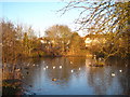
Stamford Green pond
On the north east corner of Epsom Common.
Image: © Rod Allday
Taken: 6 Mar 2010
0.19 miles