IMAGES TAKEN NEAR TO
Glanville Way, EPSOM, KT19 8HQ
Introduction
This page details the photographs taken nearby to Glanville Way, KT19 8HQ by members of the Geograph project.
The Geograph project started in 2005 with the aim of publishing, organising and preserving representative images for every square kilometre of Great Britain, Ireland and the Isle of Man.

There are currently over 7.5m images from over14,400 individuals and you can help contribute to the project by visiting https://www.geograph.org.uk
Image Map
Images are licensed for reuse under creativecommons.org/licenses/by-sa/2.0
Notes
- Clicking on the map will re-center to the selected point.
- The higher the marker number, the further away the image location is from the centre of the postcode.
Image Listing (68 Images Found)
Images are licensed for reuse under creativecommons.org/licenses/by-sa/2.0
Image
Details
Distance
1
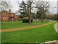
Derelict wards at West Park Hospital
West Park Hospital began life as a large psychiatric institution opened in 1924 to house London's insane. Although the buildings and grounds take up most of the central area of this grid square, only a handful are now in use, the rest having closed in the 1990s-2000s. Most of the wards are now standing derelict.
Image: © Dan Gregory
Taken: 4 Oct 2009
0.00 miles
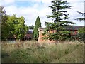
2
Noble Park
Housing converted from former hospital buildings of West Park Mental Hospital. Seen here are Frinton Court and Parklands Court on Glanville Way.
Image: © Ian Capper
Taken: 20 Jul 2018
0.02 miles
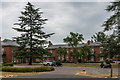
3
Noble Park
Converted psychiatric hospital, these being some of the retained buildings from West Park Hospital.
Image: © Hugh Venables
Taken: 30 Dec 2015
0.03 miles
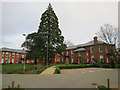
4
Noble Park
Housing converted from former hospital buildings of West Park Mental Hospital. Seen here are Janeford Court, Frinton Court and Parklands Court on Glanville Way.
Image: © Ian Capper
Taken: 20 Jul 2018
0.03 miles
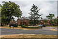
5
Noble Park
Converted psychiatric hospital, these being some of the retained buildings from West Park Hospital.
Image: © Hugh Venables
Taken: 30 Dec 2015
0.04 miles
6
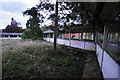
Corridor, West Park Hospital
The last great psychiatric hospital to be built in the UK, West Park Hospital was part of the Epsom Cluster that consisted of 5 similar institutions located near Epsom. The design consisted of a central group of larger buildings and a prominent water tower with long corridors radiating outwards to link outlying villas. The corridors in the picture have now been demolished but some buildings have been retained during the ongoing conversion of the site into a housing development.
Image: © Noel Jenkins
Taken: 3 Oct 2009
0.05 miles
7
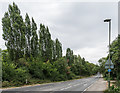
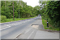
Christ Church Road
The B280 Christ Church Road on the outskirts of Epsom, as it passes Epsom Common (off the right of the photo). On the left is a Coal Tax Post (no 118 on the list linked to below) - see Image for a close up.
Image: © Ian Capper
Taken: 20 Jul 2018
0.06 miles
8
Noble Park
Converted psychiatric hospital, this being one of the retained buildings from West Park Hospital.
Image: © Hugh Venables
Taken: 30 Dec 2015
0.06 miles
9
Christchurch Road, Epsom
Looking east along Christchurch Road from the entrance to the Epsom Common car park.
Image: © Alan Hunt
Taken: 15 Jun 2015
0.06 miles
10
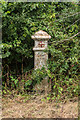
Coal Tax Post no 118
This Coal Tax Post (no 118 on the list linked to below) is on the north side of the B280 Christ Church Road on the outskirts of Epsom - see Image for a wider view.
Image: © Ian Capper
Taken: 20 Jul 2018
0.06 miles