IMAGES TAKEN NEAR TO
Temple Road, EPSOM, KT19 8HA
Introduction
This page details the photographs taken nearby to Temple Road, KT19 8HA by members of the Geograph project.
The Geograph project started in 2005 with the aim of publishing, organising and preserving representative images for every square kilometre of Great Britain, Ireland and the Isle of Man.

There are currently over 7.5m images from over14,400 individuals and you can help contribute to the project by visiting https://www.geograph.org.uk
Image Map
Images are licensed for reuse under creativecommons.org/licenses/by-sa/2.0
Notes
- Clicking on the map will re-center to the selected point.
- The higher the marker number, the further away the image location is from the centre of the postcode.
Image Listing (23 Images Found)
Images are licensed for reuse under creativecommons.org/licenses/by-sa/2.0
Image
Details
Distance
1
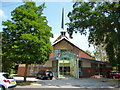
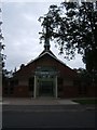
Epsom: St. Barnabas' Church
Showing that a modern church can still be an attractive building.
Image: © Dr Neil Clifton
Taken: 21 Jul 2013
0.01 miles
2
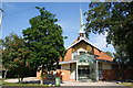
St Barnabas Church, Epsom
One of the newest buildings on Temple Road.
Image: © Bill Boaden
Taken: 1 Aug 2011
0.01 miles
3
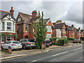
Temple Road
Late 19th/early 20th Century housing, first marked on the 1913 25 inch map.
Image: © Ian Capper
Taken: 4 Oct 2019
0.02 miles
4
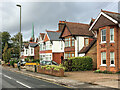
Temple Road
Late 19th/early 20th Century housing, first marked on the 1913 25 inch map. In the background is the spire of St Barnabas' Church.
Image: © Ian Capper
Taken: 4 Oct 2019
0.02 miles
5
St Barnabas Church, Temple Road, Epsom
Image: © Roger Miller
Taken: 27 Aug 2005
0.04 miles
6
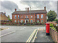
Epsom Islamic Centre
Mosque in Hook Road, seen from Miles Road. The building was originally the church hall for St Barnabas' Church in Temple Road. For a close up of the Victorian post box on the right, see Image
Image: © Ian Capper
Taken: 4 Oct 2019
0.07 miles
7
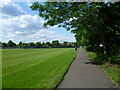
Court Recreation Ground
Court Recreation Ground is just north of the centre of Epsom, beyond the station. This path runs along the eastern edge.
Image: © Marathon
Taken: 14 May 2014
0.07 miles
8
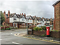
Miles Road/Hook Road junction
Junction of Miles Road with Hook Road. The houses in the background date from the late 19th/early 19th Century, and are first marked on the 1913 25 inch map. For a close up of the Victorian post box on the right, see Image
Image: © Ian Capper
Taken: 4 Oct 2019
0.07 miles
9
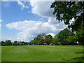
Court Recreation Ground
Court Recreation Ground is just north of the centre of Epsom, beyond the station.
Image: © Marathon
Taken: 14 May 2014
0.08 miles
10
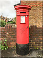
Victorian postbox, Miles Road
Victorian postbox on Miles Road, by its junction with Hook Road. For wider views see Image and Image
Image: © Ian Capper
Taken: 4 Oct 2019
0.08 miles