IMAGES TAKEN NEAR TO
Maple Close, EPSOM, KT19 8FR
Introduction
This page details the photographs taken nearby to Maple Close, KT19 8FR by members of the Geograph project.
The Geograph project started in 2005 with the aim of publishing, organising and preserving representative images for every square kilometre of Great Britain, Ireland and the Isle of Man.

There are currently over 7.5m images from over14,400 individuals and you can help contribute to the project by visiting https://www.geograph.org.uk
Image Map
Images are licensed for reuse under creativecommons.org/licenses/by-sa/2.0
Notes
- Clicking on the map will re-center to the selected point.
- The higher the marker number, the further away the image location is from the centre of the postcode.
Image Listing (16 Images Found)
Images are licensed for reuse under creativecommons.org/licenses/by-sa/2.0
Image
Details
Distance
1
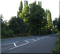
Horton Cemetery
The trees mark the site of the Horton Cemetery which contains the remains of 4,000 patients of the cluster of mental hospitals in the Epsom area. The cemetery was in use from 1899 to 1958.
Image: © Roger Miller
Taken: 5 Aug 2005
0.15 miles
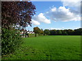
2
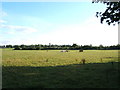
Pasture, Horton Farm
Taken from TQ 201 626 looking south.
Image: © Roger Miller
Taken: 5 Aug 2005
0.15 miles
3
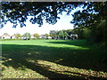
Chessington Road Recreation Ground
Chessington Road Recreation Ground (or Bakers Field) was purchased on 16th October 1930 by Epsom & Ewell Borough Council for £1,000. This view looks towards Chessington Road in the distance.
Image: © Marathon
Taken: 23 Oct 2013
0.15 miles
4
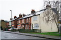
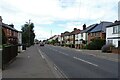
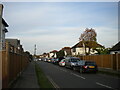
West Ewell
Houses beside the Chessington Road.
Image: © Peter Trimming
Taken: 4 Mar 2020
0.16 miles
7
Chessington Road Recreation Ground
Chessington Road Recreation Ground (or Bakers Field) was purchased on 16th October 1930 by Epsom & Ewell Borough Council for £1,000. This view looks along the boundary with Chessington Road which is on the left.
Image: © Marathon
Taken: 23 Oct 2013
0.18 miles
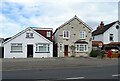
8
Jubilee Parade, Chessington Road
Built 1935 according to the inscription, and if there is any doubt, A.D.
Image: © Robin Webster
Taken: 10 Apr 2012
0.18 miles
9
Belfield Road, Ewell
Off Chessington Road.
Image: © Richard Vince
Taken: 29 Oct 2022
0.18 miles
10
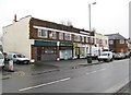
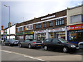
Ewell: Jubilee Parade, Chessington Road
This Jubilee Parade dates from 1935 in celebration of the Silver Jubilee of King George V. Unwins Wine Merchants appears to have closed. The road is the B2200 Chessington Road.
Image: © Nigel Cox
Taken: 19 Jan 2009
0.19 miles