IMAGES TAKEN NEAR TO
Eastman Way, EPSOM, KT19 8FH
Introduction
This page details the photographs taken nearby to Eastman Way, KT19 8FH by members of the Geograph project.
The Geograph project started in 2005 with the aim of publishing, organising and preserving representative images for every square kilometre of Great Britain, Ireland and the Isle of Man.

There are currently over 7.5m images from over14,400 individuals and you can help contribute to the project by visiting https://www.geograph.org.uk
Image Map
Images are licensed for reuse under creativecommons.org/licenses/by-sa/2.0
Notes
- Clicking on the map will re-center to the selected point.
- The higher the marker number, the further away the image location is from the centre of the postcode.
Image Listing (5 Images Found)
Images are licensed for reuse under creativecommons.org/licenses/by-sa/2.0
Image
Details
Distance
1
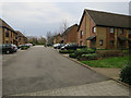
Epsom: Horton Gardens
A cupola adorns the top of the central houses in this curved terrace off Horton Hill.
Image: © Nigel Cox
Taken: 16 Mar 2006
0.16 miles
2

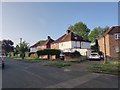
Housing development on former Horton Hospital site
Horton Hospital, one of five psychiatric hospitals clustered to the west of Epsom closed in 1997 and has been largely redeveloped as housing. The old water tower, having been retained, is a still prominent local landmark.
Image: © Dan Gregory
Taken: 7 Sep 2009
0.17 miles
3
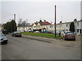
Boarded up chapel
Presumably associated with the former psychiatric hospital.
Image: © Hugh Venables
Taken: 30 Dec 2015
0.24 miles