IMAGES TAKEN NEAR TO
Ripley Way, EPSOM, KT19 7DB
Introduction
This page details the photographs taken nearby to Ripley Way, KT19 7DB by members of the Geograph project.
The Geograph project started in 2005 with the aim of publishing, organising and preserving representative images for every square kilometre of Great Britain, Ireland and the Isle of Man.

There are currently over 7.5m images from over14,400 individuals and you can help contribute to the project by visiting https://www.geograph.org.uk
Image Map
Images are licensed for reuse under creativecommons.org/licenses/by-sa/2.0
Notes
- Clicking on the map will re-center to the selected point.
- The higher the marker number, the further away the image location is from the centre of the postcode.
Image Listing (21 Images Found)
Images are licensed for reuse under creativecommons.org/licenses/by-sa/2.0
Image
Details
Distance
4
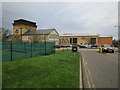
Information Centre, Horton Country Park
Image: © Hugh Venables
Taken: 30 Dec 2015
0.16 miles
5

Car park and picnic area at Horton Park
Image: © Mike Pennington
Taken: 17 Nov 2017
0.17 miles
7
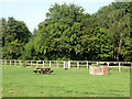
Barbecue site, Horton Country Park
One of several close to the car park, hidden behind the trees.
Image: © Robin Webster
Taken: 3 Sep 2012
0.18 miles
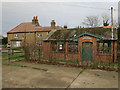
8
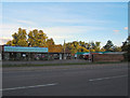
Old Moat Garden Centre
Taken from TQ 190 614 looking east.
Image: © Roger Miller
Taken: 5 Aug 2005
0.19 miles
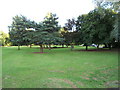
10
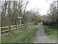
Path near Epsom
A short path linking a public bridleway and a nearby road in Surrey countryside, near Epsom.
Trees were bare, indicating that this image was taken during the winter.
Image: © Malc McDonald
Taken: 25 Feb 2023
0.19 miles