IMAGES TAKEN NEAR TO
Walsingham Gardens, EPSOM, KT19 0LT
Introduction
This page details the photographs taken nearby to Walsingham Gardens, KT19 0LT by members of the Geograph project.
The Geograph project started in 2005 with the aim of publishing, organising and preserving representative images for every square kilometre of Great Britain, Ireland and the Isle of Man.

There are currently over 7.5m images from over14,400 individuals and you can help contribute to the project by visiting https://www.geograph.org.uk
Image Map
Images are licensed for reuse under creativecommons.org/licenses/by-sa/2.0
Notes
- Clicking on the map will re-center to the selected point.
- The higher the marker number, the further away the image location is from the centre of the postcode.
Image Listing (35 Images Found)
Images are licensed for reuse under creativecommons.org/licenses/by-sa/2.0
Image
Details
Distance
1
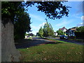
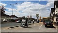
Firswood Avenue, Ewell
This view looks up Firswood Avenue from the junction with the busy Kingston Road (A240).
Image: © Marathon
Taken: 23 Oct 2013
0.13 miles
3
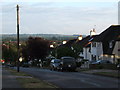
View from Newbury Gardens, Stoneleigh
Taken from TQ 219 643 looking south. The grandstand at Epsom Racecourse can be seen on the horizon.
Image: © Roger Miller
Taken: 18 Jul 2005
0.17 miles
5
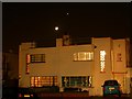
"Moderne" style house in Stoneleigh, Surrey
Stoneleigh is a 1930s housing development, with mostly traditional style buildings. There are a small number in a more interesting style.
The picture also shows a crescent moon and the planet Venus.
Image: © Jim Easterbrook
Taken: 24 Jan 2004
0.17 miles
6
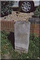
Old Milestone by the A240, Kingston Road, Ewell parish
Carved stone post by the A240, in parish of EWELL (EPSOM AND EWELL District), Kingston Road, by No.226, West of Railway bridge, on grass between path and wall, on East side of road. Surrey limestone pillar, erected by the Epsom, Ewell, Tooting etc. turnpike trust in the 18th century.
Inscription reads:-
: REIGATE / 10 : : 1 / MILE / TO / EWELL : : KINGSTON / 4 : : EWELL / PARISH :
Grade II listed.
List Entry Number: 1277168 https://historicengland.org.uk/listing/the-list/list-entry/1277168
Milestone Society National ID: SY_EWKG01.
Image: © JR Dowding & Colin Woodward
Taken: 23 Oct 2005
0.17 miles
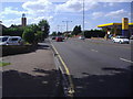
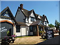
8
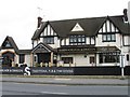
The Queen Adelaide, Ewell
The Queen Adelaide pub and carvery in Kingston Road.
Image: © Phillip Perry
Taken: 13 May 2012
0.18 miles
9
Ewell: The 'Queen Adelaide and Dragon'
A combined Thai restaurant with attached pub. I'm not sure how well this would play - but, if it's your scene ... there it is.
Image: © Dr Neil Clifton
Taken: 19 Jul 2013
0.18 miles
10
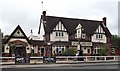
Queen Adelaide
Large and established public house on the Kingston Road, Ewell.
http://en.wikipedia.org/wiki/Ewell
Image: © Colin Smith
Taken: 3 Jul 2012
0.18 miles