IMAGES TAKEN NEAR TO
Riverview Road, EPSOM, KT19 0JQ
Introduction
This page details the photographs taken nearby to Riverview Road, KT19 0JQ by members of the Geograph project.
The Geograph project started in 2005 with the aim of publishing, organising and preserving representative images for every square kilometre of Great Britain, Ireland and the Isle of Man.

There are currently over 7.5m images from over14,400 individuals and you can help contribute to the project by visiting https://www.geograph.org.uk
Image Map
Images are licensed for reuse under creativecommons.org/licenses/by-sa/2.0
Notes
- Clicking on the map will re-center to the selected point.
- The higher the marker number, the further away the image location is from the centre of the postcode.
Image Listing (46 Images Found)
Images are licensed for reuse under creativecommons.org/licenses/by-sa/2.0
Image
Details
Distance
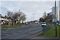
2
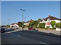
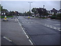
Ruxley Lane - West Ewell
The A284 to Epsom.
Image: © James Emmans
Taken: 9 May 2020
0.09 miles
3
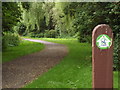
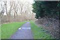
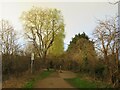
London Loop, Ewell
London Outer Orbital Path (LOOP), here following the bank of the River Hogsmill.
http://www.walklondon.org.uk/route.asp?R=5
Image: © Colin Smith
Taken: 3 Jul 2012
0.09 miles
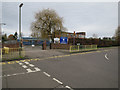
7
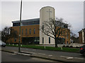
St Francis of Assisi church, Ruxley Lane
Shared through a Church of England and Methodist Local Ecumenical Partnership. Built in 2013.
Image: © Hugh Venables
Taken: 30 Dec 2015
0.11 miles

9
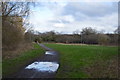
London LOOP at West Ewell
A view along the London LOOP path at West Ewell, in Surrey, taken late in the afternoon on a February day.
Image: © Malc McDonald
Taken: 25 Feb 2023
0.12 miles