IMAGES TAKEN NEAR TO
Rosebank, EPSOM, KT18 7RS
Introduction
This page details the photographs taken nearby to Rosebank, KT18 7RS by members of the Geograph project.
The Geograph project started in 2005 with the aim of publishing, organising and preserving representative images for every square kilometre of Great Britain, Ireland and the Isle of Man.

There are currently over 7.5m images from over14,400 individuals and you can help contribute to the project by visiting https://www.geograph.org.uk
Image Map
Images are licensed for reuse under creativecommons.org/licenses/by-sa/2.0
Notes
- Clicking on the map will re-center to the selected point.
- The higher the marker number, the further away the image location is from the centre of the postcode.
Image Listing (28 Images Found)
Images are licensed for reuse under creativecommons.org/licenses/by-sa/2.0
Image
Details
Distance
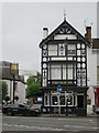
3
St Joseph's Roman Catholic Church, Epsom
Image: © Roger Miller
Taken: 9 Oct 2005
0.13 miles
6
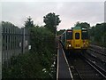
Class 455 in the Down Siding
A Class 455 unit waits briefly in the Down Siding before returning to the platform with a Victoria via Hackbridge service.
Image: © Tony Rispoli
Taken: 17 Jun 2011
0.15 miles
7
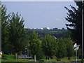
View from St Margarets Drive, Epsom
The racecourse is on the horizon
Image: © David Howard
Taken: 9 Aug 2009
0.15 miles
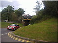
8
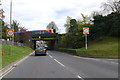
Train on Railway Bridge
A train (unit No. 450115) crossing the bridge over West St. the B280, just west of Epsom station on the Epsom to leatherhead line
Image: © Nigel Mykura
Taken: 17 Apr 2015
0.17 miles
10
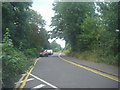
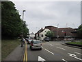
West Hill at the junction of Wheelers Lane
Image: © David Howard
Taken: 20 Aug 2012
0.18 miles