IMAGES TAKEN NEAR TO
St. Theresa Close, EPSOM, KT18 7LD
Introduction
This page details the photographs taken nearby to St. Theresa Close, KT18 7LD by members of the Geograph project.
The Geograph project started in 2005 with the aim of publishing, organising and preserving representative images for every square kilometre of Great Britain, Ireland and the Isle of Man.

There are currently over 7.5m images from over14,400 individuals and you can help contribute to the project by visiting https://www.geograph.org.uk
Image Map
Images are licensed for reuse under creativecommons.org/licenses/by-sa/2.0
Notes
- Clicking on the map will re-center to the selected point.
- The higher the marker number, the further away the image location is from the centre of the postcode.
Image Listing (17 Images Found)
Images are licensed for reuse under creativecommons.org/licenses/by-sa/2.0
Image
Details
Distance
1
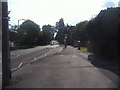
Road leading up to St Joseph's Church
Image: © Roger Miller
Taken: 9 Oct 2005
0.03 miles
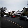
2
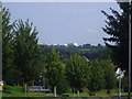
View from St Margarets Drive, Epsom
The racecourse is on the horizon
Image: © David Howard
Taken: 9 Aug 2009
0.08 miles
3
St Joseph's Roman Catholic Church, Epsom
Image: © Roger Miller
Taken: 9 Oct 2005
0.10 miles
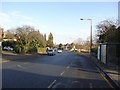
4
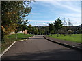
White Horse Drive
Detached houses on a Cul-de-Sac road.
Image: © James Emmans
Taken: 14 Nov 2019
0.13 miles
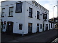
7

'White Horse', Dorking Road, Epsom, Surrey
This public house very near to Epsom General Hospital, seen in the background, serves as the terminus for two long bus routes: the 166, from West Croydon via Coulsdon (front bus, Arriva DWL) and the 293, from Morden Station (rear bus, Quality Line Optare). Whether the hospital patients are allowed to nip into the 'White Horse' for a quick one is not known.
Image: © Dr Neil Clifton
Taken: 27 Feb 2007
0.16 miles
8
Orchard Gardens
1930s cul-de-sac built in the walled kitchen garden of The Elms, a large house slightly further to the east, now called Hardy House. Part of the original garden wall can be seen on the left; dating from the 18th Century, it is grade II listed - see www.historicengland.org.uk/listing/the-list/list-entry/1213469.
Image: © Ian Capper
Taken: 27 Oct 2017
0.17 miles
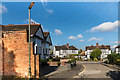
9
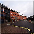
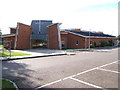
Epsom General Hospital
Rear entrance for the car park.
Image: © James Emmans
Taken: 14 Nov 2019
0.18 miles