IMAGES TAKEN NEAR TO
Woodlands Road, EPSOM, KT18 7HW
Introduction
This page details the photographs taken nearby to Woodlands Road, KT18 7HW by members of the Geograph project.
The Geograph project started in 2005 with the aim of publishing, organising and preserving representative images for every square kilometre of Great Britain, Ireland and the Isle of Man.

There are currently over 7.5m images from over14,400 individuals and you can help contribute to the project by visiting https://www.geograph.org.uk
Image Map
Images are licensed for reuse under creativecommons.org/licenses/by-sa/2.0
Notes
- Clicking on the map will re-center to the selected point.
- The higher the marker number, the further away the image location is from the centre of the postcode.
Image Listing (42 Images Found)
Images are licensed for reuse under creativecommons.org/licenses/by-sa/2.0
Image
Details
Distance
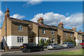
1
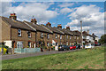
Woodlands Road
A road of mainly late Victorian/early 20th Century cottages built on what was originally part of Wells Farm in the middle of Epsom Common. This terrace has a date plaque "S 1902 T".
Image: © Ian Capper
Taken: 7 Sep 2018
0.01 miles
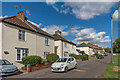
2
Woodlands Road
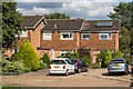
A road of mainly late Victorian/early 20th Century cottages (although the pair of houses on the left of the photo are clearly more modern) built on what was originally part of Wells Farm in the middle of Epsom Common.
Image: © Ian Capper
Taken: 7 Sep 2018
0.02 miles
3
Woodlands Road
A road of mainly late Victorian/early 20th Century cottages built on what was originally part of Wells Farm in the middle of Epsom Common.
Image: © Ian Capper
Taken: 7 Sep 2018
0.02 miles
4
Woodlands Road
A road of mainly late Victorian/early 20th Century cottages built on what was originally part of Wells Farm in the middle of Epsom Common.
Image: © Ian Capper
Taken: 7 Sep 2018
0.02 miles
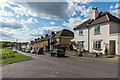
6
Woodlands Road
A road of mainly late Victorian/early 20th Century cottages built on what was originally part of Wells Farm in the middle of Epsom Common. This terrace has plaques which together read "Woodland Cottages 1894".
Image: © Ian Capper
Taken: 7 Sep 2018
0.08 miles
7
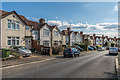
The Greenway
1930s housing in The Greenway, which forms the outer circle of The Wells.
Image: © Ian Capper
Taken: 7 Sep 2018
0.08 miles
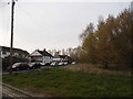
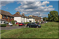
9
Marney's Close
c1970s housing in a cul-de-sac off the end of Woodlands Road
Image: © Ian Capper
Taken: 7 Sep 2018
0.08 miles
10
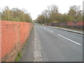
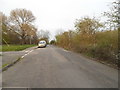
Wells Road going over the railway, Epsom
This leads to The Wells, a circular development of residential roads leading absolutely nowhere.
Image: © David Howard
Taken: 30 Mar 2014
0.11 miles