IMAGES TAKEN NEAR TO
Worple Road, EPSOM, KT18 7AA
Introduction
This page details the photographs taken nearby to Worple Road, KT18 7AA by members of the Geograph project.
The Geograph project started in 2005 with the aim of publishing, organising and preserving representative images for every square kilometre of Great Britain, Ireland and the Isle of Man.

There are currently over 7.5m images from over14,400 individuals and you can help contribute to the project by visiting https://www.geograph.org.uk
Image Map
Images are licensed for reuse under creativecommons.org/licenses/by-sa/2.0
Notes
- Clicking on the map will re-center to the selected point.
- The higher the marker number, the further away the image location is from the centre of the postcode.
Image Listing (15 Images Found)
Images are licensed for reuse under creativecommons.org/licenses/by-sa/2.0
Image
Details
Distance
1
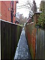
Alleyway off Avenue Road
This alleyway (Epsom & Ewell footpath 120) is barely wide enough to pass two people (and they'd have to pass sideways on). In common with most alleyways in Epsom, it follows the alignment of old field paths, and is bounded by tall brick walls which formerly enclosed villas built outside the town centre. The path originally provided a link between Madans Walk and Worple Road, which predated the laying out of Avenue Road.
Image: © Hugh Craddock
Taken: 5 Feb 2012
0.06 miles
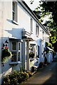
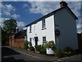
3
The Flint House
On the corner of Ashley Road and Worple Road.
Image: © Robin Webster
Taken: 10 Apr 2012
0.10 miles
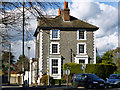
4
35 and 37 Ashley Road Epsom
This was built somewhere between 1880 and 1896 if maps are to be believed.
Image: © Robin Webster
Taken: 10 Apr 2012
0.14 miles
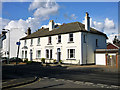
6
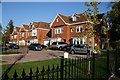
The Roseberys
Recent development (c.2007) by Mansard Homes, located between Chartwell Place and Downs Hill Road (with private access to the latter, through gate just right of photo).
Image: © Hugh Craddock
Taken: 12 Oct 2008
0.15 miles
7
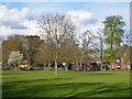
Rosebery Park, Epsom
The project the crane was assisting was not investigated.
Image: © Robin Webster
Taken: 10 Apr 2012
0.21 miles
8
Cottage in Chalk Lane
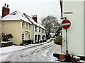
Chalk Lane is an old route leading from the centre of Epsom up to Epsom Downs. It is used by both cars and pedestrians but fortunately is not too busy. Here it has nearly reached Woodcote Road on the way into Epsom, passing another attractive group of buildings. Worple Road is on the right.
Image: © Marathon
Taken: 14 May 2014
0.21 miles
9
Chalk Lane
Chalk Lane north towards The Ladas from the junction with Worple Road. On the left hand side of the road are a number of weatherboarded cottages characteristic of Epsom.
Image: © Hugh Craddock
Taken: 5 Feb 2012
0.22 miles
10
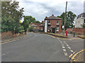
The ex-Ladas
The Ladas was a pub on the corner of Woodcote Road and Madans Walk, named (in common with several other pubs locally) after a Derby winner: in this case, the 1894 winner. And in common with several other pubs locally, it has closed — in 2011, and subsequently was converted to residential accommodation.
To the left of the letter box are Royal Automobile Club signs pointing to Woodcote Park and Epsom. These have carefully been preserved, as Woodcote Park is the country premises of the Club — notwithstanding that the RAC motoring organisation (formerly responsible for these signs) and the Club have long since gone their separate ways.
To the right is Chalk Lane, which leads up to Epsom Downs.
Image: © Hugh Craddock
Taken: 3 Jun 2020
0.23 miles