IMAGES TAKEN NEAR TO
Headley Common Road, EPSOM, KT18 6NJ
Introduction
This page details the photographs taken nearby to Headley Common Road, KT18 6NJ by members of the Geograph project.
The Geograph project started in 2005 with the aim of publishing, organising and preserving representative images for every square kilometre of Great Britain, Ireland and the Isle of Man.

There are currently over 7.5m images from over14,400 individuals and you can help contribute to the project by visiting https://www.geograph.org.uk
Image Map
Images are licensed for reuse under creativecommons.org/licenses/by-sa/2.0
Notes
- Clicking on the map will re-center to the selected point.
- The higher the marker number, the further away the image location is from the centre of the postcode.
Image Listing (34 Images Found)
Images are licensed for reuse under creativecommons.org/licenses/by-sa/2.0
Image
Details
Distance
1
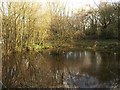
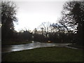
Pond, Headley Heath
The pond, at the north edge of Headley Heath, is beside bridleway BW495.
Image: © Derek Harper
Taken: 3 Feb 2011
0.03 miles
2
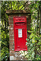
Victorian postbox
Victorian postbox in Nut Ash Lane, a short section of road connecting Tot Hill and Church Lane. See Image and Image for wider views.
Image: © Ian Capper
Taken: 12 May 2017
0.08 miles
3
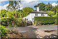
The Heath, Nut Ash Lane
House in Nut Ash Lane, a short section of road connecting Tot Hill and Church Lane. On the left is the Victorian postbox in Image with "Heath View" behind it.
Image: © Ian Capper
Taken: 12 May 2017
0.09 miles
4
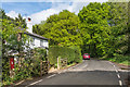
Nut Ash Lane
Short section of road connecting Tot Hill and Church Lane. On the far left is the Victorian postbox in Image with "The Heath" beyond.
Image: © Ian Capper
Taken: 12 May 2017
0.09 miles
5
Church Lane at the junction of Leech Lane
Image: © David Howard
Taken: 10 Jan 2016
0.10 miles
6
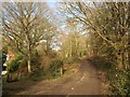
Edge of Headley Heath
Bridleway BW495 passes the corner of an intake on the north edge of the heath.
Image: © Derek Harper
Taken: 3 Feb 2011
0.10 miles
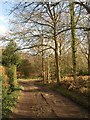
7
Tye Lane
This bridleway leads from Headley to the B2032 (Dorking Road) at Little Heath. It is on the route of the London Green Belt way.
Image: © Sean Davis
Taken: 5 Sep 2010
0.11 miles
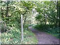
8
Edge of Headley Heath
Bridleway BW496 approaches the junction with 495 and the corner from which Image was taken.
Image: © Derek Harper
Taken: 3 Feb 2011
0.12 miles
9
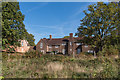
Goodman's Furze
Large house on the edge of Headley Heath built in 1932 for the architect William Curtis Green to his own design.
Image: © Ian Capper
Taken: 5 Oct 2018
0.14 miles
10
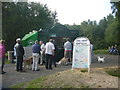
Tea Shop Headley Heath
Notice how popular this is with dog owners. This is on the route of 2012 Olympic Cycle Road Race and the London Green Belt Way.
Image: © Sean Davis
Taken: 5 Sep 2010
0.14 miles