IMAGES TAKEN NEAR TO
Church Lane, EPSOM, KT18 6LQ
Introduction
This page details the photographs taken nearby to Church Lane, KT18 6LQ by members of the Geograph project.
The Geograph project started in 2005 with the aim of publishing, organising and preserving representative images for every square kilometre of Great Britain, Ireland and the Isle of Man.

There are currently over 7.5m images from over14,400 individuals and you can help contribute to the project by visiting https://www.geograph.org.uk
Image Map
Images are licensed for reuse under creativecommons.org/licenses/by-sa/2.0
Notes
- Clicking on the map will re-center to the selected point.
- The higher the marker number, the further away the image location is from the centre of the postcode.
Image Listing (63 Images Found)
Images are licensed for reuse under creativecommons.org/licenses/by-sa/2.0
Image
Details
Distance
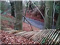
1
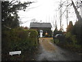
Top of Slough Lane, Headley
The lane shown in Image reaches a T-junction with Church Lane at this little triangular green.
Image: © Derek Harper
Taken: 3 Feb 2011
0.02 miles
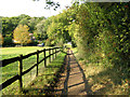
2
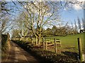
Slough Lane, Headley
The field on the right slopes up to The Old School House, which can just be seen.
Image: © Derek Harper
Taken: 3 Feb 2011
0.04 miles
4
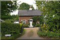
The Old School House
Despite its name, this cottage was apparently not the village school.
Image: © Ian Capper
Taken: 30 Aug 2010
0.07 miles
6
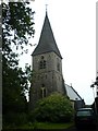
Headley Parish Church
The Church of St. Mary the Virgin, parish of Headley with Box Hill. This church was erected in the 1850s and consecrated in 1860. It stands on the site of an older building, first recorded in 1270. The Rector from 1916 to 1941 was Theodore Evelyn Reece Phillips, who as well as being rector was an internationally famous astronomer and was president and secretary of The British Astronomical Society.
Image: © Hywel Williams
Taken: 7 Jul 2005
0.08 miles
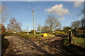
7
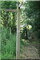
Footpath guidepost and kissing gate
Footpath sign at junction of public footpaths Headley 504 and 504a, which connect Church Lane with Slough Lane and Tumber Street. In the background, on the path to Church Lane, is a tall iron kissing gate, which remains in use.
Image: © Hugh Craddock
Taken: 1 Jun 2014
0.08 miles
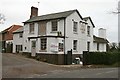
8
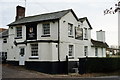
Headley Hills
Formerly the 'Cock Inn', and I remember it as a quiet country pub. Now more of an up-market restaurant/bar, but still very happy to welcome a walker on a cold day; roaring fire and good food and beer.
Image: © Peter Trimming
Taken: 9 Dec 2014
0.09 miles