IMAGES TAKEN NEAR TO
Church Lane, EPSOM, KT18 6LP
Introduction
This page details the photographs taken nearby to Church Lane, KT18 6LP by members of the Geograph project.
The Geograph project started in 2005 with the aim of publishing, organising and preserving representative images for every square kilometre of Great Britain, Ireland and the Isle of Man.

There are currently over 7.5m images from over14,400 individuals and you can help contribute to the project by visiting https://www.geograph.org.uk
Image Map
Images are licensed for reuse under creativecommons.org/licenses/by-sa/2.0
Notes
- Clicking on the map will re-center to the selected point.
- The higher the marker number, the further away the image location is from the centre of the postcode.
Image Listing (55 Images Found)
Images are licensed for reuse under creativecommons.org/licenses/by-sa/2.0
Image
Details
Distance
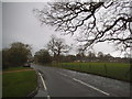
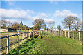
2
Footpath
Footpath FP499 which runs north/south around 250m but parallel to Church Lane in Headley.
Image: © Ian Capper
Taken: 10 Jan 2020
0.09 miles
4
Headley Church from the south
The spire of St Mary's signals the way forward along this public footpath, which runs parallel to, but behind, the buildings along Church Lane.
Image: © Hugh Craddock
Taken: 21 Dec 2008
0.11 miles
5
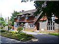
Village Hall Stores, Headley
South of the church (spire to left) is the building on Church Lane which contains both village shop and hall. It has an interesting mix of tilehung flint and brick.
Image: © Colin Smith
Taken: 10 Jul 2009
0.11 miles
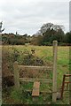
6
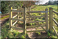
Alan's Gate
Kissing gate on footpath FP499, which runs north/south around 250m but parallel to Church Lane in Headley. I have not been able to ascertain who Alan was.
Image: © Ian Capper
Taken: 10 Jan 2020
0.12 miles
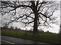
7
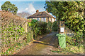
The Old Rectory
Victorian house which served as the rectory for St Mary's Church until the 1970s. It suffered bomb damage in July 1944.
Image: © Ian Capper
Taken: 10 Jan 2020
0.13 miles
8
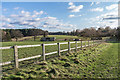
Footpath
Footpath FP499 which runs north/south around 250m but parallel to Church Lane in Headley. In the background are horse pastures which are the main land use for the area through which it passes.
Image: © Ian Capper
Taken: 10 Jan 2020
0.14 miles
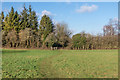
9
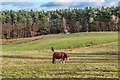
Horses
Horses feeding in one of a number of horse pastures which is the main land use for the area east of Headley. In the background is Costal Wood.
Image: © Ian Capper
Taken: 10 Jan 2020
0.14 miles
10
Footpath
Footpath FP499 which runs north/south around 250m but parallel to Church Lane in Headley. In the left background is the spire of St Mary's Church.
Image: © Ian Capper
Taken: 10 Jan 2020
0.15 miles