IMAGES TAKEN NEAR TO
Clay Lane, EPSOM, KT18 6JS
Introduction
This page details the photographs taken nearby to Clay Lane, KT18 6JS by members of the Geograph project.
The Geograph project started in 2005 with the aim of publishing, organising and preserving representative images for every square kilometre of Great Britain, Ireland and the Isle of Man.

There are currently over 7.5m images from over14,400 individuals and you can help contribute to the project by visiting https://www.geograph.org.uk
Image Map
Images are licensed for reuse under creativecommons.org/licenses/by-sa/2.0
Notes
- Clicking on the map will re-center to the selected point.
- The higher the marker number, the further away the image location is from the centre of the postcode.
Image Listing (17 Images Found)
Images are licensed for reuse under creativecommons.org/licenses/by-sa/2.0
Image
Details
Distance
1
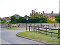
Lee Green Lane
Road junction on the North Downs with a wall made from local flint, a common stone from the chalky base.
Image: © Colin Smith
Taken: 10 Jul 2009
0.10 miles
2
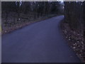
The Drive, Headley
Private road leading to the golf club
Image: © David Howard
Taken: 23 Jan 2011
0.11 miles
3
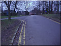
The Drive, Headley
Headley Court barracks can just be seen ahead
Image: © David Howard
Taken: 23 Jan 2011
0.11 miles
4
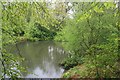
Nower Wood
Man-made pond at Nower Wood, managed by the Surrey Wildlife Trust.
Image: © Paul E Smith
Taken: 2 May 2010
0.12 miles
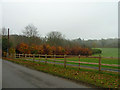
5
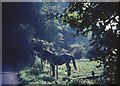
Horses by Clay Lane, Headley
The copse behind contains a chalk quarry - fossiliferous in 1965, certainly. The field is today fairly rough grazing, but the fence doesn't look so different.
Image: © Derek Harper
Taken: 24 Sep 1965
0.12 miles
6
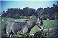
Horse and paddock, Headley
One of the horses by Clay Lane shown in Image Behind is a paddock with jumping equipment; on the far side are trees, mainly copper beeches, surrounding Court Farm. These are still there nearly 50 years later.
Image: © Derek Harper
Taken: 24 Sep 1965
0.12 miles
7
The Drive
Private road leading into Tyrrell's Wood and Tyrrell's Wood Golf Club.
Image: © Ian Capper
Taken: 6 May 2013
0.14 miles
8
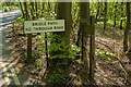
Sign, The Drive
Sign at the entrance to The Drive, a private road leading into Tyrrell's Wood and Tyrrell's Wood Golf Club. For wider view see Image
Image: © Ian Capper
Taken: 6 May 2013
0.14 miles
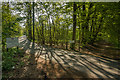
9
Beech hedge near Headley Court
The wall of Headley Court is just behind the view point.
Image: © Robin Webster
Taken: 14 Nov 2011
0.15 miles
10
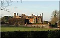
Headley Court
The house, in "Jacobethan style", was completed in 1899 http://www.britishlistedbuildings.co.uk/en-487900-headley-court-and-attached-former-stable . It's what's inside that is of importance, historically; the building contains much rescued panelling and woodwork from the C17 and C19.
From the listed building description: "Walter Cunliffe, later 1st Baron Cunliffe and the Governor of the Bank of England, was given the original farmhouse estate of some 300 acres in 1880 by his father on the condition that he would make a career in banking rather than become a farmer. The family fortune had been made by Walter's grandfather, James Cunliffe, with his development of the North Eastern Railway on which Stevenson's "Rocket" ran. 1940-45, the house was requisitioned as a Canadian Forces Headquarters. After the war it was purchased by the Trustees of the Royal Air Force Pilots and Crews Fund, raised as a memorial by the Chartered Auctioneers and Estate Agents Institute, and leased to the RAD as a rehabilitation centre".
Image: © Derek Harper
Taken: 3 Feb 2011
0.16 miles