IMAGES TAKEN NEAR TO
Stable Close, EPSOM, KT18 6HH
Introduction
This page details the photographs taken nearby to Stable Close, KT18 6HH by members of the Geograph project.
The Geograph project started in 2005 with the aim of publishing, organising and preserving representative images for every square kilometre of Great Britain, Ireland and the Isle of Man.

There are currently over 7.5m images from over14,400 individuals and you can help contribute to the project by visiting https://www.geograph.org.uk
Image Map
Images are licensed for reuse under creativecommons.org/licenses/by-sa/2.0
Notes
- Clicking on the map will re-center to the selected point.
- The higher the marker number, the further away the image location is from the centre of the postcode.
Image Listing (44 Images Found)
Images are licensed for reuse under creativecommons.org/licenses/by-sa/2.0
Image
Details
Distance
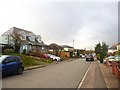
1
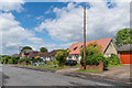
Beaconsfield Road
Housing in Langley Vale.
Image: © Ian Capper
Taken: 9 Jun 2017
0.06 miles
2
Beaconsfield Road
Housing in Langley Vale.
Image: © Ian Capper
Taken: 9 Jun 2017
0.06 miles
3
Beaconsfield Road
Housing in Langley Vale.
Image: © Ian Capper
Taken: 9 Jun 2017
0.09 miles
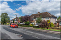
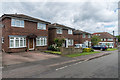
5
Grosvenor Road, Langley Vale
Dr Neil Clifton was here before me: http://www.geograph.org.uk/photo/3597559
There are three streets here built along a downland valley, and the road comes to a dead-end just behind the camera. Epsom race-course is a few minutes' walk away.
Incidentally - the grey-painted house on the left (with verandah) is plainly modern, but weather-boarded - perhaps following some Antipodean example.
Image: © Stefan Czapski
Taken: 18 Jan 2018
0.14 miles
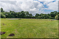
6
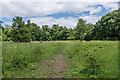
The Warren
Area of grassland off Walton Downs, thought to have originally been a hare warren.
Image: © Ian Capper
Taken: 9 Jun 2017
0.15 miles
7
Harding Road
Housing in Harding Road. In the background is the former shop on the crossroads with Grosvenor Road (see Image).
Image: © Ian Capper
Taken: 9 Jun 2017
0.16 miles
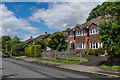
8
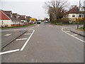
Grosvenor Road at the junction of Harding Road
Image: © David Howard
Taken: 30 Mar 2014
0.16 miles
9
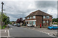
Grosvenor Road
Former shop in Grosvenor Road, by its crossroads with Harding Road.
Image: © Ian Capper
Taken: 9 Jun 2017
0.17 miles
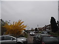
10
Langley Vale recreation ground
Recreation ground in the southeast corner of Langley Vale.
Image: © Ian Capper
Taken: 9 Jun 2017
0.17 miles