IMAGES TAKEN NEAR TO
Farm Lane, EPSOM, KT18 6BZ
Introduction
This page details the photographs taken nearby to Farm Lane, KT18 6BZ by members of the Geograph project.
The Geograph project started in 2005 with the aim of publishing, organising and preserving representative images for every square kilometre of Great Britain, Ireland and the Isle of Man.

There are currently over 7.5m images from over14,400 individuals and you can help contribute to the project by visiting https://www.geograph.org.uk
Image Map
Images are licensed for reuse under creativecommons.org/licenses/by-sa/2.0
Notes
- Clicking on the map will re-center to the selected point.
- The higher the marker number, the further away the image location is from the centre of the postcode.
Image Listing (13 Images Found)
Images are licensed for reuse under creativecommons.org/licenses/by-sa/2.0
Image
Details
Distance
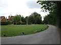
1
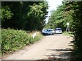
Shepherds Walk (Stane Street)
looking north towards the junction with Farm Lane (left) and Headley Road (ahead/right)
Image: © Andrew Longton
Taken: 14 Sep 2005
0.03 miles
2
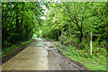
Shepherd's Walk
Bridleway on the southern outskirts of Ashtead.
Image: © Ian Capper
Taken: 19 May 2017
0.04 miles
3
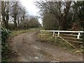
Drive to the Limes
Driveway off Shepherd's Walk (bridleway 117) to the Limes, a former racing yard. Lined, presumably, with lime trees, the driveway has a horse ride on the downside of the drive, for horses to reach the gallops on the downs. John Benstead trained here until 1998
Image: © Hugh Craddock
Taken: 31 Mar 2020
0.05 miles
4
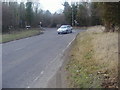
Headley Road by the junction of Downs Road
Like too many other British roads, Downs Road uses part Headley Road to change its name for a few hundred yards before splitting off for another few hundred yards and becoming Langley Vale. There is no excuse for such careless naming in the 20th century, let alone the 21st, to have a road overlapping its name with another and making it become split in two parts with another name stuck in the middle.
Image: © David Howard
Taken: 20 Feb 2012
0.07 miles
6
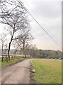
Shepherd's Walk near Ermyn Lodge Stud
Much of the countryside hereabouts is devoted to equestrian purposes. The metalled track - a private road but a public bridleway - runs out a few hundred yards ahead, going no further than the racing stables at Thirty Acre Barn.
The alignment of the Roman road known as Stane Street runs roughly parallel and a short distance to the west.
Most of the trees here are beeches.
Image: © Stefan Czapski
Taken: 21 Feb 2018
0.13 miles
7
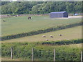
Grazing by Larch Field
Sheep grazing on a downland field south of Ashtead. Hedgerows and fences line the fields.
Image: © Colin Smith
Taken: 29 May 2011
0.14 miles
8
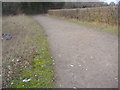
Bridleway off Headley Road near Ashtead
Image: © David Howard
Taken: 20 Feb 2012
0.17 miles
9
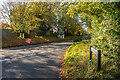
Downs Road
Downs Road where it is met by Headley Road. In the left background, by the "Road closed ahead" sign, is a Coal Tax Post (no 125 on the list linked to below). For a close up of the post, see Image
Image: © Ian Capper
Taken: 27 Oct 2017
0.19 miles
10
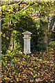
Coal Tax Post no 125
This Coal Tax Post (no 125 on the list linked to below) is situated alongside Downs Road, almost opposite Headley Road - see Image for wider view. Grade II listed - see www.historicengland.org.uk/listing/the-list/list-entry/1277035.
Image: © Ian Capper
Taken: 27 Oct 2017
0.19 miles