IMAGES TAKEN NEAR TO
Rosebery Road, EPSOM, KT18 6AE
Introduction
This page details the photographs taken nearby to Rosebery Road, KT18 6AE by members of the Geograph project.
The Geograph project started in 2005 with the aim of publishing, organising and preserving representative images for every square kilometre of Great Britain, Ireland and the Isle of Man.

There are currently over 7.5m images from over14,400 individuals and you can help contribute to the project by visiting https://www.geograph.org.uk
Image Map
Images are licensed for reuse under creativecommons.org/licenses/by-sa/2.0
Notes
- Clicking on the map will re-center to the selected point.
- The higher the marker number, the further away the image location is from the centre of the postcode.
Image Listing (52 Images Found)
Images are licensed for reuse under creativecommons.org/licenses/by-sa/2.0
Image
Details
Distance
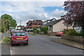
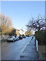
2
Langley Vale: Rosebery Road after rain
View downhill towards the Epsom-Headley road.
Image: © Stefan Czapski
Taken: 25 Jan 2018
0.04 miles
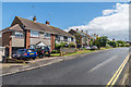
3
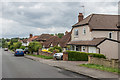
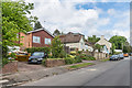
Grosvenor Road
Housing in Grosvenor Road.
Image: © Ian Capper
Taken: 9 Jun 2017
0.04 miles
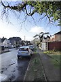
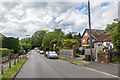
6
Langley Vale: Rosebery Road after rain (2)
View uphill (and ESE) from near the junction with the main Epsom-Headley road.
Image: © Stefan Czapski
Taken: 25 Jan 2018
0.05 miles
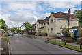
8
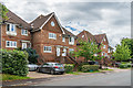
Grosvenor Mews
Housing in Grosvenor Road.
Image: © Ian Capper
Taken: 9 Jun 2017
0.07 miles
10
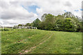
Alongside a gallop
Path alongside a gallop at the corner of Epsom Downs.
Image: © Ian Capper
Taken: 12 May 2017
0.07 miles