IMAGES TAKEN NEAR TO
Treadwell Road, EPSOM, KT18 5JX
Introduction
This page details the photographs taken nearby to Treadwell Road, KT18 5JX by members of the Geograph project.
The Geograph project started in 2005 with the aim of publishing, organising and preserving representative images for every square kilometre of Great Britain, Ireland and the Isle of Man.

There are currently over 7.5m images from over14,400 individuals and you can help contribute to the project by visiting https://www.geograph.org.uk
Image Map
Images are licensed for reuse under creativecommons.org/licenses/by-sa/2.0
Notes
- Clicking on the map will re-center to the selected point.
- The higher the marker number, the further away the image location is from the centre of the postcode.
Image Listing (11 Images Found)
Images are licensed for reuse under creativecommons.org/licenses/by-sa/2.0
Image
Details
Distance
1
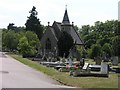
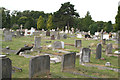
Epsom Cemetery
Epsom Cemetery with the cemetery chapel
Image: © Hywel Williams
Taken: 13 Jul 2005
0.11 miles
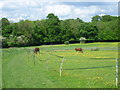
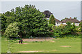
3
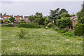
Paddock
Paddock off Rifle Butts Alley. The houses in the background are in Aston Way.
Image: © Ian Capper
Taken: 8 Jun 2018
0.16 miles
4
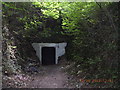
The 'secret' Epsom underground shelter
Image: © Geoff Marshall
Taken: 10 Sep 2003
0.18 miles
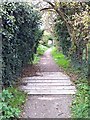
5
Footpath to Ashley Road
Viewed from just after leaving Chalk Lane, this footpath cuts across a horse pasture before passing through some woodland to reach Ashley Road.
Image: © Marathon
Taken: 14 May 2014
0.21 miles
6
Rifle Butts Alley (3): the sump
The sleepers placed across the bridleway here cover a sump or catch-pit, which is designed to intercept excess rainwater descending the path: during wet weather, the volume of water draining into Treadwell Road below could otherwise contribute to flooding of nearby homes.
Image: © Hugh Craddock
Taken: 17 Nov 2013
0.21 miles
7
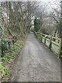
Bottom of Rifle Butts Alley
Looking up Rifle Butts Alley from near the catch-pit Image, following the improvement works in early 2022. The path has now been restored to its original width between the fence and the railings on the left-hand side.
Image: © Hugh Craddock
Taken: 14 Feb 2022
0.22 miles
8
Paddock
Paddock off Rifle Butts Alley. The houses in the background are in Downs Way.
Image: © Ian Capper
Taken: 8 Jun 2018
0.22 miles
9
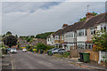
Beech Road
Cul-de-sac off Burgh Heath Road. This section is first shown in the 1934 1:2,500 map.
Image: © Ian Capper
Taken: 8 Jun 2018
0.23 miles