IMAGES TAKEN NEAR TO
Worple Road, EPSOM, KT18 5EJ
Introduction
This page details the photographs taken nearby to Worple Road, KT18 5EJ by members of the Geograph project.
The Geograph project started in 2005 with the aim of publishing, organising and preserving representative images for every square kilometre of Great Britain, Ireland and the Isle of Man.

There are currently over 7.5m images from over14,400 individuals and you can help contribute to the project by visiting https://www.geograph.org.uk
Image Map
Images are licensed for reuse under creativecommons.org/licenses/by-sa/2.0
Notes
- Clicking on the map will re-center to the selected point.
- The higher the marker number, the further away the image location is from the centre of the postcode.
Image Listing (91 Images Found)
Images are licensed for reuse under creativecommons.org/licenses/by-sa/2.0
Image
Details
Distance
1
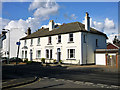
35 and 37 Ashley Road Epsom
This was built somewhere between 1880 and 1896 if maps are to be believed.
Image: © Robin Webster
Taken: 10 Apr 2012
0.02 miles
2
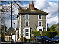
The Flint House
On the corner of Ashley Road and Worple Road.
Image: © Robin Webster
Taken: 10 Apr 2012
0.06 miles
5
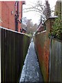
Alleyway off Avenue Road
This alleyway (Epsom & Ewell footpath 120) is barely wide enough to pass two people (and they'd have to pass sideways on). In common with most alleyways in Epsom, it follows the alignment of old field paths, and is bounded by tall brick walls which formerly enclosed villas built outside the town centre. The path originally provided a link between Madans Walk and Worple Road, which predated the laying out of Avenue Road.
Image: © Hugh Craddock
Taken: 5 Feb 2012
0.12 miles
6
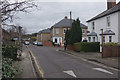
Heathcote Road, Epsom
Looking towards the junction with Laburnum Road.
Image: © Stephen McKay
Taken: 22 Dec 2014
0.12 miles
7
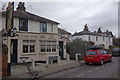
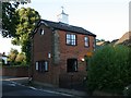
The Rising Sun, Epsom
Back street pub on Heathcote Road, a short walk from the town centre.
Image: © Stephen McKay
Taken: 22 Dec 2014
0.13 miles
9
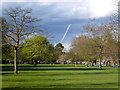
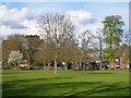
Rosebery Park, Epsom
The project the crane was assisting was not investigated.
Image: © Robin Webster
Taken: 10 Apr 2012
0.14 miles
10
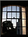
King's Lodge from the alleyway
King's Lodge, an office block at 28 Church Street, seen through an old window frame set into the wall of the alleyway linking Church Street and Downside.
Image: © Hugh Craddock
Taken: 15 Jul 2008
0.17 miles