IMAGES TAKEN NEAR TO
Burgh Heath Road, EPSOM, KT17 4NT
Introduction
This page details the photographs taken nearby to Burgh Heath Road, KT17 4NT by members of the Geograph project.
The Geograph project started in 2005 with the aim of publishing, organising and preserving representative images for every square kilometre of Great Britain, Ireland and the Isle of Man.

There are currently over 7.5m images from over14,400 individuals and you can help contribute to the project by visiting https://www.geograph.org.uk
Image Map
Images are licensed for reuse under creativecommons.org/licenses/by-sa/2.0
Notes
- Clicking on the map will re-center to the selected point.
- The higher the marker number, the further away the image location is from the centre of the postcode.
Image Listing (26 Images Found)
Images are licensed for reuse under creativecommons.org/licenses/by-sa/2.0
Image
Details
Distance
1
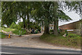
Wendover Stables
Stables on Burgh Heath Road.
Image: © Ian Capper
Taken: 8 Jun 2018
0.09 miles
2
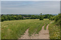
Epsom Downs
An area of grassland off Epsom Downs, with extensive views to the northwest.
Image: © Ian Capper
Taken: 8 Jun 2018
0.17 miles
3
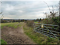
Gate into private property (keep out)
An open gate off Epsom Downs, much used by horses going to and from one of the several racing establishments around the downs.
Image: © Robin Webster
Taken: 23 Nov 2010
0.17 miles
4
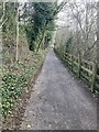
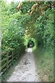
Rifle Butts Alley (half way up)
Half way up Rifle Butts Alley, following the improvement works in early 2022. For a comparison with pre-2022, see Image
Image: © Hugh Craddock
Taken: 14 Feb 2022
0.19 miles
5
Rifle Butts Alley (2)
Looking down Rifle Butts Alley, towards Beech Road. View looking south: Image
Image: © Hugh Craddock
Taken: 6 Aug 2010
0.19 miles
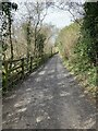
6
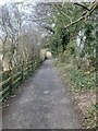
Rifle Butts Alley (near the top)
Rifle Butts Alley, looking downhill from near the top, following the improvement works in early 2022.
Image: © Hugh Craddock
Taken: 14 Feb 2022
0.20 miles
7
Rifle Butts Alley (top 100m)
Rifle Butts Alley, looking uphill towards the top, where it opens out onto Epsom downs. This is following the improvement works in early 2022: seen here Image temporally about mid-way between the previous improvement (in the late 1990s) and the present one.
Image: © Hugh Craddock
Taken: 14 Feb 2022
0.20 miles
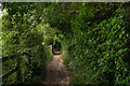
8
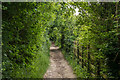
Rifle Butts Alley
Footpath connecting Epsom Downs with the town, running along a dry valley. Its name comes from the fact that the area was used as a training ground for the 8th Corps of the Surrey Rifle Volunteers in the late 19th Century.
Image: © Ian Capper
Taken: 8 Jun 2018
0.20 miles
9
Rifle Butts Alley
Footpath connecting Epsom Downs with the town, running along a dry valley. Its name comes from the fact that the area was used as a training ground for the 8th Corps of the Surrey Rifle Volunteers in the late 19th Century.
Image: © Ian Capper
Taken: 8 Jun 2018
0.21 miles
10
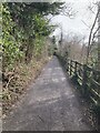
Rifle Butts Alley (from the top)
Rifle Butts Alley, looking downhill from the top, following the improvement works in early 2022.
Image: © Hugh Craddock
Taken: 14 Feb 2022
0.21 miles