IMAGES TAKEN NEAR TO
Mospey Crescent, EPSOM, KT17 4NA
Introduction
This page details the photographs taken nearby to Mospey Crescent, KT17 4NA by members of the Geograph project.
The Geograph project started in 2005 with the aim of publishing, organising and preserving representative images for every square kilometre of Great Britain, Ireland and the Isle of Man.

There are currently over 7.5m images from over14,400 individuals and you can help contribute to the project by visiting https://www.geograph.org.uk
Image Map
Images are licensed for reuse under creativecommons.org/licenses/by-sa/2.0
Notes
- Clicking on the map will re-center to the selected point.
- The higher the marker number, the further away the image location is from the centre of the postcode.
Image Listing (17 Images Found)
Images are licensed for reuse under creativecommons.org/licenses/by-sa/2.0
Image
Details
Distance
1
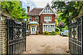
51 Burgh Heath Road
Late Victorian house in Burgh Heath Road.
Image: © Ian Capper
Taken: 8 Jun 2018
0.11 miles
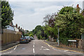
2
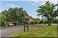
Burghfield
1960s development off Burgh Heath Road.
Image: © Ian Capper
Taken: 8 Jun 2018
0.11 miles
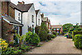
3
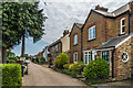
Carter's Road
Private road off Burgh Heath Road. Some of the cottages are shown on the 1871 1:10,560 map, marked as Down Cottages. The 1895-6 1:2500 map was largely unchanged, with the addition of only a few additional cottages, but by then they were named Carter's Cottages. By the time of the 1913 1:2,500 map, development was complete, but still with the name Carter's Cottages. The name Carter's Road first appears on the 1934 1:2,500 map. To add further name into the mix, the plaque on the front of the second pair of cottages in this photo is inscribed "Herbert Cottages 1899".
Image: © Ian Capper
Taken: 8 Jun 2018
0.14 miles
4
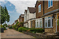
Carter's Road
Private road off Burgh Heath Road. Some of the cottages are shown on the 1871 1:10,560 map, marked as Down Cottages. The 1895-6 1:2500 map was largely unchanged, with the addition of only a few additional cottages, but by then they were named Carter's Cottages. By the time of the 1913 1:2,500 map, development was complete, but still with the name Carter's Cottages. The name Carter's Road first appears on the 1934 1:2,500 map.
Image: © Ian Capper
Taken: 8 Jun 2018
0.15 miles
5
Treadwell Road
Road off Burgh Heath Road shown on the 1895-6 1:2,500 map as Loop Road without any development. However the 1913 map shows some building, including the terraced housing just visible on the left hand side of the road.
Image: © Ian Capper
Taken: 8 Jun 2018
0.15 miles
6
Beech Way
Cul-de-sac off Burgh Heath Road first shown on the 1934 1:2,500 map.
Image: © Ian Capper
Taken: 8 Jun 2018
0.15 miles
7
Carter's Road
Private road off Burgh Heath Road. Some of the cottages are shown on the 1871 1:10,560 map, marked as Down Cottages. The 1895-6 1:2500 map was largely unchanged, with the addition of only a few additional cottages, but by then they were named Carter's Cottages. By the time of the 1913 1:2,500 map, development was complete, but still with the name Carter's Cottages. The name Carter's Road first appears on the 1934 1:2,500 map.
Image: © Ian Capper
Taken: 8 Jun 2018
0.15 miles
8
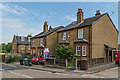
Ivy Cottages and Myrtle Cottages
Two pairs of semi-detached cottages in Burgh Heath Road, dating from around the turn of the 19th/20th Centuries.
Image: © Ian Capper
Taken: 8 Jun 2018
0.16 miles
9
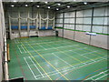
Sports hall at Epsom College
The sports centre has two large halls and several smaller ones for particular sports, for example one has provision for fencing and also has a climbing wall. This one is laid out for a variety of sports, hence the variety of coloured lines. It has provision for cricket nets, providing indoor cricket practice.
Image: © David Hawgood
Taken: 2 Jun 2010
0.17 miles
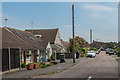
10
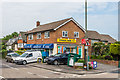
Corner Shop 4 U
Corner shop by the junction of Beech Road with Burgh Heath Road
Image: © Ian Capper
Taken: 8 Jun 2018
0.18 miles