IMAGES TAKEN NEAR TO
Cedar Close, EPSOM, KT17 4HG
Introduction
This page details the photographs taken nearby to Cedar Close, KT17 4HG by members of the Geograph project.
The Geograph project started in 2005 with the aim of publishing, organising and preserving representative images for every square kilometre of Great Britain, Ireland and the Isle of Man.

There are currently over 7.5m images from over14,400 individuals and you can help contribute to the project by visiting https://www.geograph.org.uk
Image Map
Images are licensed for reuse under creativecommons.org/licenses/by-sa/2.0
Notes
- Clicking on the map will re-center to the selected point.
- The higher the marker number, the further away the image location is from the centre of the postcode.
Image Listing (103 Images Found)
Images are licensed for reuse under creativecommons.org/licenses/by-sa/2.0
Image
Details
Distance
1
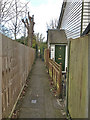
Cottages off College Road
Several vernacular weatherboarded cottages are hidden off College Road (but numbered in College Road), down a public footpath Epsom & Ewell 110/townpath T6070, which links College Road with Albert Road.
Image: © Hugh Craddock
Taken: 29 Mar 2020
0.04 miles
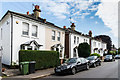
2
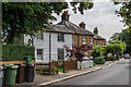
25 - 35 College Road
Houses in College Road. Nos 25-27 (the weather-boarded building) date from around 1840 and are grade II listed - www.historicengland.org.uk/listing/the-list/list-entry/1044734 - with the houses beyond dating from the turn of the 19th/20th Centuries.
Image: © Ian Capper
Taken: 8 Jun 2018
0.06 miles
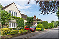
3
32 College Road
c1850 house in College Road at its junction with Lynwood Road. Grade II listed - see www.historicengland.org.uk/listing/the-list/list-entry/1044736.
Image: © Ian Capper
Taken: 8 Jun 2018
0.07 miles
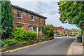
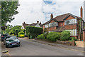
4
College Road
Houses in College Road at its junction with Lynwood Road. Most of these date from the 1930s or so, although those partly visible in the background are late Victorian.
Image: © Ian Capper
Taken: 8 Jun 2018
0.07 miles
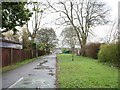
5
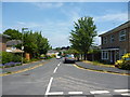
Epsom: Tintagel Close
Looking north along this up-market cul-de-sac
Image: © Dr Neil Clifton
Taken: 21 Jul 2013
0.08 miles
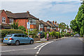
6

Albert Road
Road connecting Church Road and College Road (from which this photo was taken foreground), progressively developed between the late 19th Century (at the Church Road end), through to the 1930s (when it appears that most of the houses in this photo were built) and the 1950s.
Image: © Ian Capper
Taken: 8 Jun 2018
0.09 miles
7
61 - 73 College Road
Lat Victorian villas in College Road.
Image: © Ian Capper
Taken: 8 Jun 2018
0.10 miles
8
12 Lynwood Road
c1920s house in Lynwood Road.
Image: © Ian Capper
Taken: 8 Jun 2018
0.13 miles
9
14 Lynwood Road
Early 20th Century house in Lynwood Road.
Image: © Ian Capper
Taken: 8 Jun 2018
0.14 miles
10
Bridle Road: bridleway
This stretch of bridleway 43 Epsom, a continuation of Bridle Road up to Alexandra Road, is surprisingly wide. It's now part of a designated cycleway between Epsom and East Ewell.
Image: © Hugh Craddock
Taken: 5 Apr 2008
0.14 miles