IMAGES TAKEN NEAR TO
Reigate Road, EPSOM, KT17 3LT
Introduction
This page details the photographs taken nearby to Reigate Road, KT17 3LT by members of the Geograph project.
The Geograph project started in 2005 with the aim of publishing, organising and preserving representative images for every square kilometre of Great Britain, Ireland and the Isle of Man.

There are currently over 7.5m images from over14,400 individuals and you can help contribute to the project by visiting https://www.geograph.org.uk
Image Map
Images are licensed for reuse under creativecommons.org/licenses/by-sa/2.0
Notes
- Clicking on the map will re-center to the selected point.
- The higher the marker number, the further away the image location is from the centre of the postcode.
Image Listing (29 Images Found)
Images are licensed for reuse under creativecommons.org/licenses/by-sa/2.0
Image
Details
Distance
1
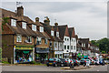
Drift Bridge shopping parade
c1930s shopping parade in Fir Tree Road, near where it crosses Reigate Road at the Drift Bridge crossroads. Fir Tree Road itself significantly predates any development, being shown on the 1871 1:10,000 map.
Image: © Ian Capper
Taken: 8 Jun 2018
0.08 miles
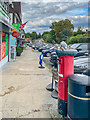
2

Postbox topper, Epsom Downs Post Office
Postbox topper on a postbox outside Epsom Downs Post Office in Fir Tree Road.
Image: © Ian Capper
Taken: 4 Aug 2022
0.08 miles
3
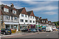
Drift Bridge shopping parade
c1930s shopping parade in Fir Tree Road, near where it crosses Reigate Road at the Drift Bridge crossroads. Fir Tree Road itself significantly predates any development, being shown on the 1871 1:10,000 map.
Image: © Ian Capper
Taken: 8 Jun 2018
0.08 miles
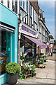
4
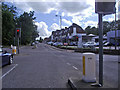
Shopping parade, Fir Tree Road
Shopping parade in Fir Tree Road. The postbox on the right has a topper (see Image).
Image: © Ian Capper
Taken: 4 Aug 2022
0.08 miles
5
Drift Bridge shopping parade
c1930s shopping parade in Fir Tree Road, near where it crosses Reigate Road at the Drift Bridge crossroads. Fir Tree Road itself significantly predates any development, being shown on the 1871 1:10,000 map.
Image: © Ian Capper
Taken: 8 Jun 2018
0.08 miles
6
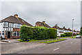
Fir Tree Road
c1930s housing in Fir Tree Road, although the road itself significantly predates any development, being shown on the 1871 1:10,000 map.
Image: © Ian Capper
Taken: 8 Jun 2018
0.08 miles
7
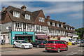
Drift Bridge shopping parade
c1930s shopping parade in Fir Tree Road, near where it crosses Reigate Road at the Drift Bridge crossroads. Fir Tree Road itself significantly predates any development, being shown on the 1871 1:10,000 map.
Image: © Ian Capper
Taken: 8 Jun 2018
0.08 miles
9
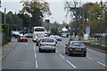
Junction of Fir Tree Road and Reigate Road
Opposite the Drift Bridge garage.
Image: © David Howard
Taken: 22 Jun 2008
0.11 miles
10

Drift Bridge Garage
Volkswagen main dealer situated at the Drift Bridge crossroads where Fir Tree Road crosses Reigate Road.
Image: © Ian Capper
Taken: 8 Jun 2018
0.11 miles