IMAGES TAKEN NEAR TO
Fir Tree Close, EPSOM, KT17 3LD
Introduction
This page details the photographs taken nearby to Fir Tree Close, KT17 3LD by members of the Geograph project.
The Geograph project started in 2005 with the aim of publishing, organising and preserving representative images for every square kilometre of Great Britain, Ireland and the Isle of Man.

There are currently over 7.5m images from over14,400 individuals and you can help contribute to the project by visiting https://www.geograph.org.uk
Image Map
Images are licensed for reuse under creativecommons.org/licenses/by-sa/2.0
Notes
- Clicking on the map will re-center to the selected point.
- The higher the marker number, the further away the image location is from the centre of the postcode.
Image Listing (49 Images Found)
Images are licensed for reuse under creativecommons.org/licenses/by-sa/2.0
Image
Details
Distance
1
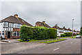
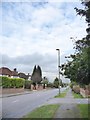
Fir Tree Road
c1930s housing in Fir Tree Road, although the road itself significantly predates any development, being shown on the 1871 1:10,000 map.
Image: © Ian Capper
Taken: 8 Jun 2018
0.05 miles
2
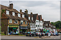
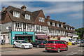
Drift Bridge shopping parade
c1930s shopping parade in Fir Tree Road, near where it crosses Reigate Road at the Drift Bridge crossroads. Fir Tree Road itself significantly predates any development, being shown on the 1871 1:10,000 map.
Image: © Ian Capper
Taken: 8 Jun 2018
0.08 miles
3

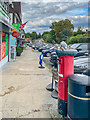
Postbox topper, Epsom Downs Post Office
Postbox topper on a postbox outside Epsom Downs Post Office in Fir Tree Road.
Image: © Ian Capper
Taken: 4 Aug 2022
0.08 miles
4
Drift Bridge shopping parade
c1930s shopping parade in Fir Tree Road, near where it crosses Reigate Road at the Drift Bridge crossroads. Fir Tree Road itself significantly predates any development, being shown on the 1871 1:10,000 map.
Image: © Ian Capper
Taken: 8 Jun 2018
0.09 miles
5
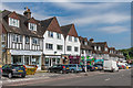
Shopping parade, Fir Tree Road
Shopping parade in Fir Tree Road. The postbox on the right has a topper (see Image).
Image: © Ian Capper
Taken: 4 Aug 2022
0.09 miles
6

Drift Bridge shopping parade
c1930s shopping parade in Fir Tree Road, near where it crosses Reigate Road at the Drift Bridge crossroads. Fir Tree Road itself significantly predates any development, being shown on the 1871 1:10,000 map.
Image: © Ian Capper
Taken: 8 Jun 2018
0.10 miles
7
Fir Tree Road (B291)
Pretty typical of the many residential streets in this outer suburban area - though this links the A240 at Drift Bridge with Epsom Downs, and thus carries a certain amount of through traffic.
The view is NNE from a point not many yards north of Mimosa Close (newly built, and not yet plotted by the OS at the time of writing).
Image: © Stefan Czapski
Taken: 18 Jan 2018
0.10 miles
8
Drift Bridge shopping parade
c1930s shopping parade in Fir Tree Road, near where it crosses Reigate Road at the Drift Bridge crossroads. Fir Tree Road itself significantly predates any development, being shown on the 1871 1:10,000 map.
Image: © Ian Capper
Taken: 8 Jun 2018
0.10 miles
9
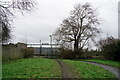
Epsom Downs
Beyond the fence is the platform of Epsom Downs station.
Image: © Peter Trimming
Taken: 26 Jan 2023
0.12 miles
10
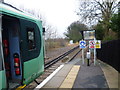
Epsom Downs station
Epsom Downs station is just a shadow of what it once was. Opened in 1865, it had nine platform faces, most of which were only used on race days. Tattenham Corner station is more convenient as it is much closer to the racecourse at Epsom Downs and consequently, as race traffic declined, there was no need for all the platforms at Epsom Downs station. Eventually only one island platform remained and then in 1989 the station was demolished to make way for a new housing estate and a new single platform station was built some 300 yards to the north-east. For more information and photographs see http://www.disused-stations.org.uk/e/epsom_downs/index.shtml During the day now there is an hourly service along the single track branch from Sutton. Here a Southern train awaits departure for Victoria via West Croydon.
Image: © Marathon
Taken: 18 Jan 2012
0.13 miles