IMAGES TAKEN NEAR TO
Banstead Road, EPSOM, KT17 3HH
Introduction
This page details the photographs taken nearby to Banstead Road, KT17 3HH by members of the Geograph project.
The Geograph project started in 2005 with the aim of publishing, organising and preserving representative images for every square kilometre of Great Britain, Ireland and the Isle of Man.

There are currently over 7.5m images from over14,400 individuals and you can help contribute to the project by visiting https://www.geograph.org.uk
Image Map
Images are licensed for reuse under creativecommons.org/licenses/by-sa/2.0
Notes
- Clicking on the map will re-center to the selected point.
- The higher the marker number, the further away the image location is from the centre of the postcode.
Image Listing (16 Images Found)
Images are licensed for reuse under creativecommons.org/licenses/by-sa/2.0
Image
Details
Distance
1
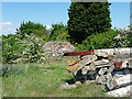
Priest Hill, East Ewell (2)
A slightly mysterious and eerie site. A path leads from the road to these piles of rubble, and adjacent overgrown areas of tarmac suggest that this was once some sort of sports ground. Why was it demolished and why has nothing taken its place?
Image: © Stephen Richards
Taken: 24 May 2010
0.04 miles
2
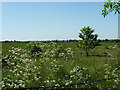
Priest Hill, East Ewell (1)
House-builders must be salivating at the sight of this site. A large expanse of open land not overtly serving any specific purpose. Presumably it must be Green Belt otherwise it would already have been built on.
Image: © Stephen Richards
Taken: Unknown
0.05 miles
3
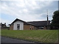
Church of the Latter Day Saints on Beverley Close
Image: © David Howard
Taken: 1 Jun 2014
0.09 miles
4
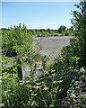
Priest Hill, East Ewell (3)
A slightly mysterious and eerie site. A path leads from the road to these overgrown areas of tarmac which, together with adjacent piles of rubble, suggest that this was once some sort of sports ground. Someone had lit a fire in the middle. Why was it demolished and why has nothing taken its place?
Image: © Stephen Richards
Taken: Unknown
0.10 miles
5
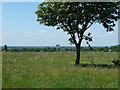
Priest Hill, East Ewell (4)
A view from this expanse of open land across south London. The prominent block is, by my reckoning, Tolworth Tower.
Image: © Stephen Richards
Taken: Unknown
0.10 miles
6
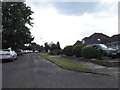
Banstead Road, East Ewell
Very green around here with lots of open land. One could almost forget one were only a few miles from Greater London.
Image: © Stephen Richards
Taken: Unknown
0.10 miles
7
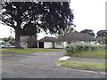
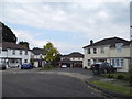
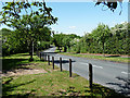
Bungalows on Beverley Close, East Ewell
Image: © David Howard
Taken: 1 Jun 2014
0.11 miles
8
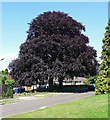
Copper Beech, East Ewell
I noticed this fine specimen on Beverley Close. I hope it has been correctly identified ...
Image: © Stephen Richards
Taken: Unknown
0.13 miles