IMAGES TAKEN NEAR TO
Kenmore Close, EPSOM, KT17 3FE
Introduction
This page details the photographs taken nearby to Kenmore Close, KT17 3FE by members of the Geograph project.
The Geograph project started in 2005 with the aim of publishing, organising and preserving representative images for every square kilometre of Great Britain, Ireland and the Isle of Man.

There are currently over 7.5m images from over14,400 individuals and you can help contribute to the project by visiting https://www.geograph.org.uk
Image Map
Images are licensed for reuse under creativecommons.org/licenses/by-sa/2.0
Notes
- Clicking on the map will re-center to the selected point.
- The higher the marker number, the further away the image location is from the centre of the postcode.
Image Listing (13 Images Found)
Images are licensed for reuse under creativecommons.org/licenses/by-sa/2.0
Image
Details
Distance
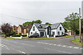
1
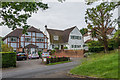
Yew Tree Bottom Road
1940s(?) housing on Yew Tree Bottom Road.
Image: © Ian Capper
Taken: 8 Jun 2018
0.06 miles
2
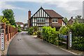
Yew Tree Close
Development off Yew Tree Bottom Road, completed in 2012.
Image: © Ian Capper
Taken: 8 Jun 2018
0.07 miles
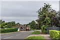
3
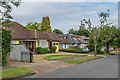
Garlichill Road
Postwar bungalows in a road off Yew Tree Bottom Road.
Image: © Ian Capper
Taken: 8 Jun 2018
0.12 miles
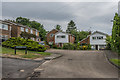
4
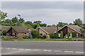
Yew Tree Bottom Road
1960s housing on Yew Tree Bottom Road, by its junction with Rose Bushes.
Image: © Ian Capper
Taken: 8 Jun 2018
0.13 miles
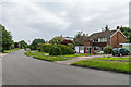
5
Junction of Downs Wood and Garlichill Road
Housing in an area first developed in around the 1940s. The house in the centre of the photo, 1 Downs Wood, was originally a bungalow which was enlarged in around 2015.
Image: © Ian Capper
Taken: 8 Jun 2018
0.14 miles
6
Rose Bushes
1960s housing built on an area of woodland, which was marked on old maps as Rose Bushes, the name being retained for this road and also applied to the whole estate.
Image: © Ian Capper
Taken: 8 Jun 2018
0.16 miles
7
Rose Bushes
1960s housing built on an area of woodland, which was marked on old maps as Rose Bushes, the name being retained for this road and also applied to the whole estate.
Image: © Ian Capper
Taken: 8 Jun 2018
0.17 miles
8
Rose Bushes
1960s housing built on an area of woodland, which was marked on old maps as Rose Bushes, the name being retained for this road and also applied to the whole estate. Albertine Close on the left is a later infill development.
Image: © Ian Capper
Taken: 8 Jun 2018
0.19 miles
9
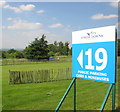
Epsom Downs public parking for The Derby
A parking area beside Grandstand Road.
Image: © David Hawgood
Taken: 2 Jun 2010
0.20 miles
10
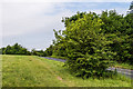
Burgh Heath Road
Burgh Heath Road as it crosses Epsom Downs from Buckle's Gap.
Image: © Ian Capper
Taken: 8 Jun 2018
0.20 miles