IMAGES TAKEN NEAR TO
Blackthorn Close, EPSOM, KT17 3DF
Introduction
This page details the photographs taken nearby to Blackthorn Close, KT17 3DF by members of the Geograph project.
The Geograph project started in 2005 with the aim of publishing, organising and preserving representative images for every square kilometre of Great Britain, Ireland and the Isle of Man.

There are currently over 7.5m images from over14,400 individuals and you can help contribute to the project by visiting https://www.geograph.org.uk
Image Map
Images are licensed for reuse under creativecommons.org/licenses/by-sa/2.0
Notes
- Clicking on the map will re-center to the selected point.
- The higher the marker number, the further away the image location is from the centre of the postcode.
Image Listing (21 Images Found)
Images are licensed for reuse under creativecommons.org/licenses/by-sa/2.0
Image
Details
Distance
1
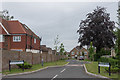
Chestnut Way
Cul-de-sac off Fir Tree Road, completed in 2016.
Image: © Ian Capper
Taken: 8 Jun 2018
0.07 miles
2
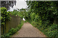
Footpath
Footpath connecting Fir Tree Road and Rose Bushes.
Image: © Ian Capper
Taken: 8 Jun 2018
0.09 miles
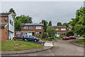
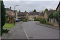
3
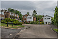
Rose Bushes
1960s housing built on an area of woodland, which was marked on old maps as Rose Bushes, the name being retained for this road and also applied to the whole estate. Albertine Close on the left is a later infill development.
Image: © Ian Capper
Taken: 8 Jun 2018
0.14 miles
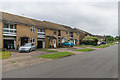
4
Nos.31-41 Rose Bushes
Spur off Rose Bushes, servicing nos.31 to 41.
Image: © Hugh Craddock
Taken: 27 Dec 2013
0.14 miles
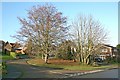
5
Rose Bushes
1960s housing built on an area of woodland, which was marked on old maps as Rose Bushes, the name being retained for this road and also applied to the whole estate.
Image: © Ian Capper
Taken: 8 Jun 2018
0.15 miles
6
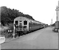
Epsom Downs station
In July 1979, Epsom Downs station was quite near Epsom Downs, but now the vast station shown in this photograph has been removed and housing built on the site. The station is now nearly half a mile further east.
The train here is '4-SUB' unit No 4721, which unusually had roller-blind route indicators fitted - almost all the 4-SUBS used stencils.
Image: © Dr Neil Clifton
Taken: 19 Jul 1979
0.16 miles
7
Yew Tree Close
Development off Yew Tree Bottom Road, completed in 2012.
Image: © Ian Capper
Taken: 8 Jun 2018
0.17 miles
8
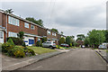
Rose Bushes
1960s housing built on an area of woodland, which was marked on old maps as Rose Bushes, the name being retained for this road and also applied to the whole estate.
Image: © Ian Capper
Taken: 8 Jun 2018
0.17 miles
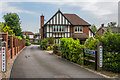
9
Bunbury Way, Epsom Downs
This hardly looks like the approach to a railway terminus, but in fact this suburban street was built on the trackbed to the original Epsom Downs station, when the branch from Sutton was cut back in 1989 - no doubt a lucrative development opportunity for British Rail at the time. Traffic to the new Epsom Downs station now has to pass this way.
Image: © Stephen McKay
Taken: 17 Mar 2008
0.17 miles
10
Rose Bushes
1960s housing built on an area of woodland, which was marked on old maps as Rose Bushes, the name being retained for this road and also applied to the whole estate.
Image: © Ian Capper
Taken: 8 Jun 2018
0.17 miles