IMAGES TAKEN NEAR TO
Whitebeam Close, EPSOM, KT17 3AU
Introduction
This page details the photographs taken nearby to Whitebeam Close, KT17 3AU by members of the Geograph project.
The Geograph project started in 2005 with the aim of publishing, organising and preserving representative images for every square kilometre of Great Britain, Ireland and the Isle of Man.

There are currently over 7.5m images from over14,400 individuals and you can help contribute to the project by visiting https://www.geograph.org.uk
Image Map
Images are licensed for reuse under creativecommons.org/licenses/by-sa/2.0
Notes
- Clicking on the map will re-center to the selected point.
- The higher the marker number, the further away the image location is from the centre of the postcode.
Image Listing (36 Images Found)
Images are licensed for reuse under creativecommons.org/licenses/by-sa/2.0
Image
Details
Distance
1
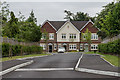
Mimosa Close
Cul-de-sac off Fir Tree Road, completed in 2017.
Image: © Ian Capper
Taken: 8 Jun 2018
0.09 miles
2
Chestnut Way
Cul-de-sac off Fir Tree Road, completed in 2016.
Image: © Ian Capper
Taken: 8 Jun 2018
0.10 miles
3
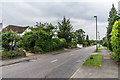
Fir Tree Road
c1930s housing in Fir Tree Road, although the road itself significantly predates any development, being shown on the 1871 1:10,000 map.
Image: © Ian Capper
Taken: 8 Jun 2018
0.12 miles
4
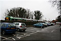
Epsom Down station (4)
This shows the small car park provided south of the platform. With a much larger car park free of charge, and a better rail service, the station could attract park-and-ride from quite a large area.
Image: © Dr Neil Clifton
Taken: 6 Dec 2007
0.12 miles
5
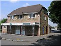
Epsom Downs Station
A relatively modern stone clad building in keeping with the newly built housing around it. The station shares its building with the Railway Children Kindergarten.
Image: © Hywel Williams
Taken: 13 Jul 2005
0.12 miles
6
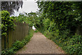
Footpath
Footpath connecting Fir Tree Road and Rose Bushes.
Image: © Ian Capper
Taken: 8 Jun 2018
0.12 miles
7
Nursery by entrance to Epsom Downs station
There was also a station building nearer the line but has since been demolished.
Image: © David Howard
Taken: 22 Jun 2008
0.14 miles
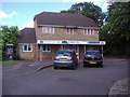
8
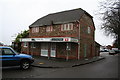
Bunbury Way, Epsom Downs
The building straight ahead, blending in well with the 1980s executive homes on this estate, is in fact Epsom Downs station - it also incorporates a children's nursery. The branch from Sutton was opened in 1865 and at first prospered as the closest station to Epsom racecourse, but that role was usurped by the Tattenham Corner branch in 1901. Since then, the line has had a purely suburban role serving the important town of Banstead but ending nowhere in particular. In 1989 the line was cut back to make way for new housing development, which at least must have offered the prospect of additional commuter traffic.
Image: © Stephen McKay
Taken: 17 Mar 2008
0.14 miles
9
Epsom Downs station (3)
This small building looks as if it might have been intended as a station house: in fact it has never been used as such, but is a kindergarten.
Image: © Dr Neil Clifton
Taken: 6 Dec 2007
0.15 miles
10
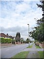
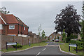
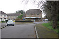
Fir Tree Road (B291)
Pretty typical of the many residential streets in this outer suburban area - though this links the A240 at Drift Bridge with Epsom Downs, and thus carries a certain amount of through traffic.
The view is NNE from a point not many yards north of Mimosa Close (newly built, and not yet plotted by the OS at the time of writing).
Image: © Stefan Czapski
Taken: 18 Jan 2018
0.15 miles