IMAGES TAKEN NEAR TO
Chelwood Close, EPSOM, KT17 3AF
Introduction
This page details the photographs taken nearby to Chelwood Close, KT17 3AF by members of the Geograph project.
The Geograph project started in 2005 with the aim of publishing, organising and preserving representative images for every square kilometre of Great Britain, Ireland and the Isle of Man.

There are currently over 7.5m images from over14,400 individuals and you can help contribute to the project by visiting https://www.geograph.org.uk
Image Map
Images are licensed for reuse under creativecommons.org/licenses/by-sa/2.0
Notes
- Clicking on the map will re-center to the selected point.
- The higher the marker number, the further away the image location is from the centre of the postcode.
Image Listing (14 Images Found)
Images are licensed for reuse under creativecommons.org/licenses/by-sa/2.0
Image
Details
Distance
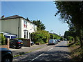
3
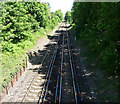
Epsom-Ewell railway
A stretch of line between Epsom and Ewell East stations, looking towards the latter.
Taken from a bridge on Windmill Lane.
Image: © Stephen Richards
Taken: Unknown
0.09 miles
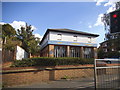
4
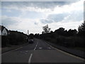
Epsom Road at the junction of Windmill Avenue
Image: © David Howard
Taken: 1 Jun 2014
0.15 miles
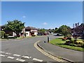
5
Ewell: Park Hill Road
Looking south
Image: © Dr Neil Clifton
Taken: 21 Jul 2013
0.16 miles
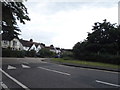
6
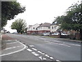
Epsom Road
I don't know the border between Epsom and Ewell but this stops being Epsom Road at the next junction so may enter it then.
Image: © David Howard
Taken: 1 Jun 2014
0.16 miles
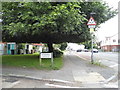
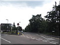
7
Windmill Close
Junction with Windmill Lane.
Image: © James Emmans
Taken: 6 May 2020
0.16 miles
8
Mill Road at the junction of Bridge Road, Epsom
Image: © David Howard
Taken: 1 Jun 2014
0.17 miles
10
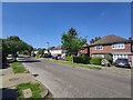
Windmill Close - Epsom
Detached houses near Wallace Fields Junior School.
Image: © James Emmans
Taken: 6 May 2020
0.21 miles