IMAGES TAKEN NEAR TO
Seymour Avenue, EPSOM, KT17 2RR
Introduction
This page details the photographs taken nearby to Seymour Avenue, KT17 2RR by members of the Geograph project.
The Geograph project started in 2005 with the aim of publishing, organising and preserving representative images for every square kilometre of Great Britain, Ireland and the Isle of Man.

There are currently over 7.5m images from over14,400 individuals and you can help contribute to the project by visiting https://www.geograph.org.uk
Image Map
Images are licensed for reuse under creativecommons.org/licenses/by-sa/2.0
Notes
- Clicking on the map will re-center to the selected point.
- The higher the marker number, the further away the image location is from the centre of the postcode.
Image Listing (16 Images Found)
Images are licensed for reuse under creativecommons.org/licenses/by-sa/2.0
Image
Details
Distance
1
Suburban Ewell
Inter-war detached housing in Ewell at the corner of Arundel and Castle Avenues.
www.epsom-ewell.gov.uk
Image: © Colin Smith
Taken: 11 Mar 2013
0.11 miles
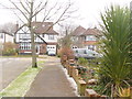
2
Ewell - Castle Avenue
Suburbia on the edges of Nonsuch Park, a historic green space which once housed Cuddington village and Nonsuch Palace. The local street names have royal connections.
www.epsom-ewell.gov.uk
Image: © Colin Smith
Taken: 11 Mar 2013
0.13 miles
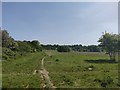
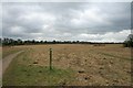
3
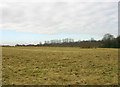
Open countryside near Ewell
Although this scene looks rural the open country hereabouts is surrounded on all sides by extensive suburban development.
Image: © David Kemp
Taken: 14 Feb 2009
0.14 miles
4
Ewell - Seymour Avenue
Suburban street of inter-war housing close to Ewell East Railway Station.
www.epsom-ewell.gov.uk
Image: © Colin Smith
Taken: 11 Mar 2013
0.16 miles
5
Warren Farm Nature Reserve
A local farm is now preserved for nature and for leisure use.
Image: © James Emmans
Taken: 9 May 2020
0.17 miles
6
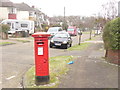
Ewell - Corner Post Box
Bright splash of Post Office Red at the corner of Parr and Seymour Avenues in suburban Ewell.
www.epsom-ewell.gov.uk
Image: © Colin Smith
Taken: 11 Mar 2013
0.18 miles
7
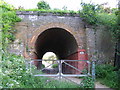
Railway bridge, East Ewell
This railway bridge provides access to the open parkland.
Image: © Brian Green
Taken: 14 May 2008
0.20 miles
8
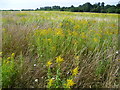
Grassland on Warren Farm
The London LOOP passes across the field of Warren Farm on its way from Ewell to Nonsuch Park. Nonsuch Park is beyond the trees in the distance.
Warren Farm was given to the Woodland Trust Reserve in 1994. In August it is colourful with the bright yellow of goldenrod as can be seen here.
Image: © Marathon
Taken: 21 Aug 2013
0.20 miles
9
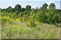
Vegetation near Nonsuch Park
This land is south of The Avenue so is not in the park. It has a pleasant yellow theme.
Image: © Bill Boaden
Taken: 1 Aug 2011
0.22 miles
10
Warren Farm
Warren Farm is owned by the Woodland Trust, and lies just to the south of Nonsuch Park. The land was given to the Trust in 1994 by a local developer.
Image: © Hugh Craddock
Taken: 22 Feb 2009
0.22 miles