IMAGES TAKEN NEAR TO
Fairfax Avenue, EPSOM, KT17 2QW
Introduction
This page details the photographs taken nearby to Fairfax Avenue, KT17 2QW by members of the Geograph project.
The Geograph project started in 2005 with the aim of publishing, organising and preserving representative images for every square kilometre of Great Britain, Ireland and the Isle of Man.

There are currently over 7.5m images from over14,400 individuals and you can help contribute to the project by visiting https://www.geograph.org.uk
Image Map
Images are licensed for reuse under creativecommons.org/licenses/by-sa/2.0
Notes
- Clicking on the map will re-center to the selected point.
- The higher the marker number, the further away the image location is from the centre of the postcode.
Image Listing (21 Images Found)
Images are licensed for reuse under creativecommons.org/licenses/by-sa/2.0
Image
Details
Distance
1
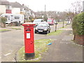
Ewell - Corner Post Box
Bright splash of Post Office Red at the corner of Parr and Seymour Avenues in suburban Ewell.
www.epsom-ewell.gov.uk
Image: © Colin Smith
Taken: 11 Mar 2013
0.08 miles
2
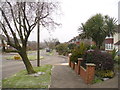
Ewell - Seymour Avenue
Suburban street of inter-war housing close to Ewell East Railway Station.
www.epsom-ewell.gov.uk
Image: © Colin Smith
Taken: 11 Mar 2013
0.10 miles
3
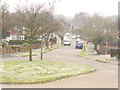
Ewell - Arundel Avenue
Commuter belt and suburbia too - inter-war housing close to Ewell East Railway Station.
www.epsom-ewell.gov.uk
Image: © Colin Smith
Taken: 11 Mar 2013
0.13 miles
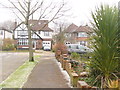
4
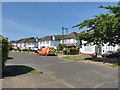
Detached Houses in Castle Avenue - Ewell
Image: © James Emmans
Taken: 9 May 2020
0.15 miles
5
Ewell - Castle Avenue
Suburbia on the edges of Nonsuch Park, a historic green space which once housed Cuddington village and Nonsuch Palace. The local street names have royal connections.
www.epsom-ewell.gov.uk
Image: © Colin Smith
Taken: 11 Mar 2013
0.17 miles
8
Suburban Ewell
Inter-war detached housing in Ewell at the corner of Arundel and Castle Avenues.
www.epsom-ewell.gov.uk
Image: © Colin Smith
Taken: 11 Mar 2013
0.20 miles
9
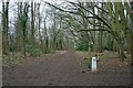
Nonsuch Park, near the Banqueting House
Junction of footpaths in the woods near the site of the Banqueting House. The London Loop path turns right here (signposted). The pillar is one of several marking the remains of Nonsuch Palace: this one points towards the Banqueting House.
Image: © Hugh Craddock
Taken: 22 Feb 2009
0.21 miles
10
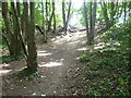
View from the London LOOP in Nonsuch Park
The London LOOP here is on its way from Banstead Downs to Ewell. It is passing through woodland on the south-western edge of Nonsuch Park. For more information on Nonsuch Park see http://www.geograph.org.uk/photo/3613690
Image: © Marathon
Taken: 21 Aug 2013
0.21 miles