IMAGES TAKEN NEAR TO
Meadow Walk, EPSOM, KT17 2ED
Introduction
This page details the photographs taken nearby to Meadow Walk, KT17 2ED by members of the Geograph project.
The Geograph project started in 2005 with the aim of publishing, organising and preserving representative images for every square kilometre of Great Britain, Ireland and the Isle of Man.

There are currently over 7.5m images from over14,400 individuals and you can help contribute to the project by visiting https://www.geograph.org.uk
Image Map
Images are licensed for reuse under creativecommons.org/licenses/by-sa/2.0
Notes
- Clicking on the map will re-center to the selected point.
- The higher the marker number, the further away the image location is from the centre of the postcode.
Image Listing (37 Images Found)
Images are licensed for reuse under creativecommons.org/licenses/by-sa/2.0
Image
Details
Distance

2
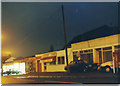
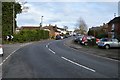
Rosebery Parade on Kingston Road, Ewell c1993
Image: © David Howard
Taken: Unknown
0.07 miles
3
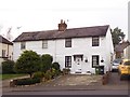
Weather-boarded cottages, Kingston Road, Ewell
In and around the old village centre at Ewell a good number of weather-boarded properties have survived - some even smaller than those in the picture. Their survival seems almost miraculous - given the great surge of residential development that overtook the wider area in the 1920s and 30s (with further in-filling post-war).
Image: © Stefan Czapski
Taken: 9 Dec 2017
0.07 miles
4
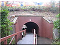
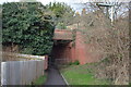
Hogsmill River walkway in Ewell
This bridge was built by the London & South Western Railway to take the tracks between Ewell West and Stoneleigh stations over the Hogsmill River, as evidenced by the passing South West Trains coaches. At some stage though a walkway has been constructed through the bridge, presumably as a means of maintaining the continuity of the London Loop public footpath. This is in Section 8 of the footpath, between Ewell and Kingston.
Image: © Nigel Cox
Taken: 19 Jan 2009
0.09 miles
7
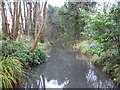
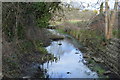
Hogsmill River in Ewell
Viewed looking upstream from the railway crossing, the river looks vaguely tropical here. Maybe it's the unusual sight of lush vegetation in January.
Image: © Nigel Cox
Taken: 19 Jan 2009
0.10 miles
8
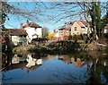
Lower Millpond. Ewell
One of a series of ponds and lakes at the source of the Hogsmill River.
Image: © Des Blenkinsopp
Taken: 26 Mar 2012
0.10 miles
9

The Loop in the Tunnel
This pre existing river culvert beneath the railway has had this causeway put through it as a convenient way of getting the London Loop Path from one side to the other.
Image: © Des Blenkinsopp
Taken: 25 Mar 2012
0.11 miles