IMAGES TAKEN NEAR TO
Cullerne Close, EPSOM, KT17 1XY
Introduction
This page details the photographs taken nearby to Cullerne Close, KT17 1XY by members of the Geograph project.
The Geograph project started in 2005 with the aim of publishing, organising and preserving representative images for every square kilometre of Great Britain, Ireland and the Isle of Man.

There are currently over 7.5m images from over14,400 individuals and you can help contribute to the project by visiting https://www.geograph.org.uk
Image Map
Images are licensed for reuse under creativecommons.org/licenses/by-sa/2.0
Notes
- Clicking on the map will re-center to the selected point.
- The higher the marker number, the further away the image location is from the centre of the postcode.
Image Listing (47 Images Found)
Images are licensed for reuse under creativecommons.org/licenses/by-sa/2.0
Image
Details
Distance
1
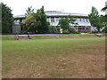
Bourne Hall, Ewell
Bourne Hall was built in 1969, replacing a 1770 building that had fallen into disrepair, and houses a library and museum together with halls and rooms used for a wide variety of social activities.
Image: © Roger Miller
Taken: 9 Jul 2005
0.09 miles
2
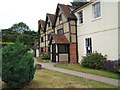
Timber framed building, Ewell c1535
This building, which was restored in 1990, used to house Fitznell's School of Music. The extension on the right is of relatively recent date.
Image: © Roger Miller
Taken: 9 Jul 2005
0.09 miles
3
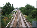
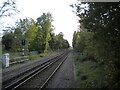
Railway line at West Ewell looking south.
Ewell West station can be seen in the distance.
Image: © Roger Miller
Taken: 9 Jul 2005
0.09 miles
5
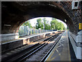
Ewell West Station, Ewell, Surrey
Looking under the road bridge on Ewell West Station, looking south.
Image: © Christine Matthews
Taken: 2 Jun 2010
0.12 miles
6
Railway south from Ewell West station
Looking towards Epsom from the south end of the Up platform.
Image: © Richard Vince
Taken: 29 Oct 2022
0.13 miles
7
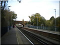
Ewell West railway station
Looking towards London Waterloo from the south end of the Up platform. The bridge carrying Chessington Road across the railway has quite a narrow arch, so the platforms are slightly lower as they pass beneath the bridge in order to provide adequate headroom.
Image: © Richard Vince
Taken: 29 Oct 2022
0.14 miles
8
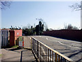
Bridge carrying Chessington Road, Ewell, Surrey
Looking east along the Chessington Road (B2200) along the bridge over the railway line at Ewell West station.
Image: © Christine Matthews
Taken: 17 Apr 2010
0.16 miles
9
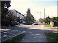
Chessington Road (B2200), Ewell, Surrey
Image: © Christine Matthews
Taken: 16 Mar 2010
0.16 miles
10
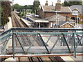
Footbridge, Ewell West
Suburban and commuters' railway station on the London-Epsom line.
www.epsomandewellhistoryexplorer.org.uk
Image: © Colin Smith
Taken: 17 Jul 2012
0.17 miles