IMAGES TAKEN NEAR TO
Stones Road, EPSOM, KT17 1DF
Introduction
This page details the photographs taken nearby to Stones Road, KT17 1DF by members of the Geograph project.
The Geograph project started in 2005 with the aim of publishing, organising and preserving representative images for every square kilometre of Great Britain, Ireland and the Isle of Man.

There are currently over 7.5m images from over14,400 individuals and you can help contribute to the project by visiting https://www.geograph.org.uk
Image Map
Images are licensed for reuse under creativecommons.org/licenses/by-sa/2.0
Notes
- Clicking on the map will re-center to the selected point.
- The higher the marker number, the further away the image location is from the centre of the postcode.
Image Listing (21 Images Found)
Images are licensed for reuse under creativecommons.org/licenses/by-sa/2.0
Image
Details
Distance
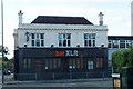
1
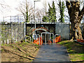
Railway bridge RPE 13/9G
The old brick arch has recently been strengthened with an inner concrete ring. For a long time the pedestrian crossing here was by overbridge, but this underbridge is evidently an old one, so what went under it? There is no sign of a watercourse on maps or on the site.
Image: © Robin Webster
Taken: 10 Apr 2012
0.08 miles
2
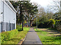
Footpath towards Stones Road
The path passes under the railway ahead.
Image: © Robin Webster
Taken: 10 Apr 2012
0.10 miles
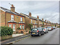
3
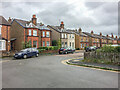
Miles Road
Late 19th/early 20th Century housing, first marked on the 1913 25 inch map.
Image: © Ian Capper
Taken: 4 Oct 2019
0.10 miles
4
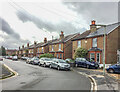
Miles Road
Late 19th/early 20th Century housing, first marked on the 1913 25 inch map. Each of these semi-detached pairs have name/date plaques; in order from right to left they are: Ellison Cottages 1899, Stanmore Cottages 1899, Lorraine Cottages 1899, Ventnor Cottages 1899, Carisbrook (sic) Cottages 1899, Glenco (sic) Cottages 1899 and Belmont Cottages 1901.
Image: © Ian Capper
Taken: 4 Oct 2019
0.15 miles
6
Miles Road
Late 19th/early 20th Century housing, first marked on the 1913 25 inch map. Each of these semi-detached pairs have name/date plaques; in order from left to right they are: Belmont Cottages 1901, Glenco (sic) Cottages 1899, Carisbrook (sic) Cottages 1899, Ventnor Cottages 1899, Lorraine Cottages 1899, Stanmore Cottages 1899 and Ellison Cottages 1899.
Image: © Ian Capper
Taken: 4 Oct 2019
0.16 miles
7
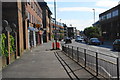
East Street, Epsom
This is the A24 north of Epsom town centre.
Image: © Bill Boaden
Taken: 1 Aug 2011
0.19 miles
8
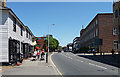
East Street, Epsom
The A24 just north of Epsom town centre. This stretch is mostly lined with medium-sized C20th office blocks, but on the left can be seen a pair of pretty weatherboarded cottages.
Image: © Stephen Richards
Taken: Unknown
0.19 miles

10
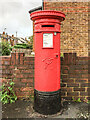
Victorian postbox, Miles Road
Victorian postbox on Miles Road, by its junction with Hook Road. For wider views see Image and Image
Image: © Ian Capper
Taken: 4 Oct 2019
0.20 miles