IMAGES TAKEN NEAR TO
Ferry Lane, CHERTSEY, KT16 8RN
Introduction
This page details the photographs taken nearby to Ferry Lane, KT16 8RN by members of the Geograph project.
The Geograph project started in 2005 with the aim of publishing, organising and preserving representative images for every square kilometre of Great Britain, Ireland and the Isle of Man.

There are currently over 7.5m images from over14,400 individuals and you can help contribute to the project by visiting https://www.geograph.org.uk
Image Map
Images are licensed for reuse under creativecommons.org/licenses/by-sa/2.0
Notes
- Clicking on the map will re-center to the selected point.
- The higher the marker number, the further away the image location is from the centre of the postcode.
Image Listing (32 Images Found)
Images are licensed for reuse under creativecommons.org/licenses/by-sa/2.0
Image
Details
Distance
1
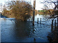
Ferry Lane, Chertsey
The water from the Burway Ditch usually flows in a culvert under Ferry Lane. During the floods of January 2014 it overflowed across the lane.
Image: © Alan Hunt
Taken: 11 Jan 2014
0.04 miles
2
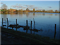
Abbey Mead, Chertsey
Flooded meads to the north of the M3. During January 2014 the Thames reminded everyone that this is its flood plain
.
Image: © Alan Hunt
Taken: 11 Jan 2014
0.06 miles
3
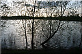
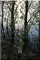
Willow Edged Gravel Pit (4)
According to the signs around here this land belongs to the Thorpe Park Theme Park, although the main part of the park is the other side of the A320.
Apparently this gravel pit is quite new see Image
Image: © David Lally
Taken: 23 Apr 2008
0.06 miles
5
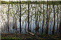
Willow Edged Gravel Pit (2)
According to the signs around here this land belongs to the Thorpe Park Theme Park, although the main part of the park is the other side of the A320.
Apparently this gravel pit is quite new see Image
Image: © David Lally
Taken: 23 Apr 2008
0.09 miles
6
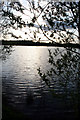
Willow Edged Gravel Pit (1)
According to the signs around here this land belongs to the Thorpe Park Theme Park, although the main part of the park is the other side of the A320.
Apparently this gravel pit is quite new see Image
Image: © David Lally
Taken: 23 Apr 2008
0.10 miles
7
Willow Edged Gravel Pit (3)
According to the signs around here this land belongs to the Thorpe Park Theme Park, although the main part of the park is the other side of the A320.
Apparently this gravel pit is quite new see Image
Image: © David Lally
Taken: 23 Apr 2008
0.12 miles
8
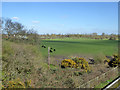
Abbey Mead north of M3, Chertsey
Looking from the Ferry Lane bridge.
Image: © Robin Webster
Taken: 16 Mar 2020
0.13 miles
9
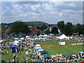
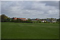
Abbey Fields Chertsey
Taken from the Big Wheel on the day of the Black Cherry Fair. St. Anne's Hill is in the background.
Image: © Alan Morrison
Taken: 13 Jul 2002
0.13 miles
10
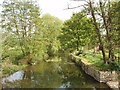
Abbey River, Chertsey
Abbey River is a sidewater of the Thames. Here it is just north of the abbey site. Photo taken from the Ferry Lane bridge over the river.
Image: © David Hawgood
Taken: 7 May 2006
0.13 miles