IMAGES TAKEN NEAR TO
Clarendon Gate, CHERTSEY, KT16 0GA
Introduction
This page details the photographs taken nearby to Clarendon Gate, KT16 0GA by members of the Geograph project.
The Geograph project started in 2005 with the aim of publishing, organising and preserving representative images for every square kilometre of Great Britain, Ireland and the Isle of Man.

There are currently over 7.5m images from over14,400 individuals and you can help contribute to the project by visiting https://www.geograph.org.uk
Image Map
Images are licensed for reuse under creativecommons.org/licenses/by-sa/2.0
Notes
- Clicking on the map will re-center to the selected point.
- The higher the marker number, the further away the image location is from the centre of the postcode.
Image Listing (27 Images Found)
Images are licensed for reuse under creativecommons.org/licenses/by-sa/2.0
Image
Details
Distance
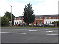
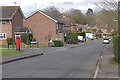
1
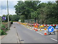
Murray Road (B3121)
Footpath goes off to the right - Image]
Image: © JThomas
Taken: 25 Jul 2022
0.08 miles
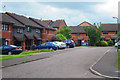
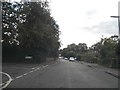
2
Murray Road, Ottershaw
Looking east along Murray Road between Ottershaw and Addlestone.
Image: © Alan Hunt
Taken: 10 Apr 2015
0.08 miles
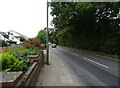
3
Slade Road, Ottershaw
Slade Road looking northeast towards the junction with Vernon Close.
Image: © Alan Hunt
Taken: 4 Apr 2016
0.09 miles
4
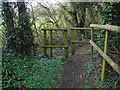
Footpath entrance off Murray Road
The footpath across the fields between Murray Road and the A320, St Peter's Way.
Image: © Alan Hunt
Taken: 10 Apr 2015
0.09 miles
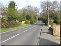
5
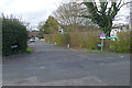
Slade Road at the junction of Rosefield Gardens
Image: © David Howard
Taken: 17 Aug 2014
0.10 miles
6
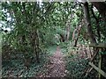
Footpath through woodland
Towards Guildford Road.
Image: © JThomas
Taken: 25 Jul 2022
0.10 miles
8
Slade Court, Ottershaw
The short access road off Slade Road.
Image: © Alan Hunt
Taken: 4 Apr 2016
0.12 miles