1
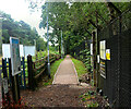
Path by the Perimeter
This path is on a narrow strip between the railway and the fence around a former MOD site. It is the less easy of the two footpaths which provide the only access to the very isolated Longcross Station.
It's not a right of way. It is supposedly closed on Christmas Day as an overgrown notice at the eastern end points out. Somehow I doubt they do.
Image: © Des Blenkinsopp
Taken: 7 Nov 2016
0.07 miles
2
Building Site at Longcross
Brownfield land at a former MOD site is being redeveloped. This could mean yet more passengers for the isolated Longcross Station nearby, which has been seeing a steady increase in footfall since the MOD moved out.
Image: © Des Blenkinsopp
Taken: 7 Nov 2016
0.09 miles
3
Footpath leading east from Longcross station
There is no road access to this station. This made-up footpath leads to the Crest Nicholson housing development at Upper Longcross.
Image: © David Kemp
Taken: 1 Jul 2023
0.10 miles
4
Sign proclaiming Upper Longcross at Longcross station
Upper Longcross is a housing development on land adjacent to the former defence establishment at Longcross and is a few minutes walk from the station along a footpath. The area around the station is now more user-friendly in appearance than earlier Geographs suggested.
Image: © David Kemp
Taken: 1 Jul 2023
0.11 miles
5
Longcross station shelter
A shelter on the platform of this remote station from the bridge over the lines.
Image: © Alan Hunt
Taken: 6 Dec 2014
0.11 miles
6
Longcross station
One of the few stations with no road access. It appears to be there principally to serve the Longcross site, formerly a military establishment but now converted into film studios. There is a security turnstile into the site from the station, and also the only public access, a path between site and railway fences leading to the end of Burma Road. On the north side there is a locked gate into Wentworth Estate property.
Image: © Robin Webster
Taken: 13 Sep 2014
0.12 miles
7
Longcross station - entrance
The facilities at and the service to Longcross have improved somewhat since the station was last Geographed in 2017. This reflects the fact that the adjacent former MoD site is now used by Longcross (film) Studios and that residential development has taken place at Upper Longcross nearby. Although there is still no direct road access the station, it is accessible along a made-up footpath. Despite the Tickets sign on the wall, the Permit to Travel machine was out of order.
Image: © David Kemp
Taken: 30 May 2023
0.12 miles
8
Longcross station, up-side
This station now looks less spartan than it did in the recent past when very few trains called there each day. A second (and locked) exit gate can be seen to the left of the steps.
Image: © David Kemp
Taken: 1 Jul 2023
0.12 miles
9
Improved Path to Longcross Station
The very isolated station at Longcross which at one time had a service of only two trains a day is seeing increased use with new housing being built nearby. Former military land is now becoming a fair sized community and this new pathway with lighting has been made along the little used track which looked like this
Image when I was last here. There is still no vehicle access to the station at present.
Image: © Des Blenkinsopp
Taken: 6 Jun 2018
0.12 miles
10
Longcross railway station, Surrey
Opened in 1942 by the Southern Railway on the line from Staines to Ascot, this station mainly served the neighbouring military establishment, an area that has since been redeveloped.
View East towards Virginia Water and Staines.
Image: © Nigel Thompson
Taken: 4 Aug 2016
0.12 miles


