IMAGES TAKEN NEAR TO
Queen Marys Drive, ADDLESTONE, KT15 3TW
Introduction
This page details the photographs taken nearby to Queen Marys Drive, KT15 3TW by members of the Geograph project.
The Geograph project started in 2005 with the aim of publishing, organising and preserving representative images for every square kilometre of Great Britain, Ireland and the Isle of Man.

There are currently over 7.5m images from over14,400 individuals and you can help contribute to the project by visiting https://www.geograph.org.uk
Image Map
Images are licensed for reuse under creativecommons.org/licenses/by-sa/2.0
Notes
- Clicking on the map will re-center to the selected point.
- The higher the marker number, the further away the image location is from the centre of the postcode.
Image Listing (12 Images Found)
Images are licensed for reuse under creativecommons.org/licenses/by-sa/2.0
Image
Details
Distance
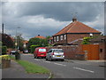
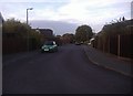
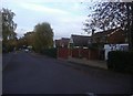
4
Junction of Aprilwood Close and Woodham Park Road
Image: © David Howard
Taken: 31 Oct 2011
0.18 miles
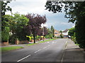
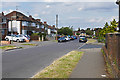
5
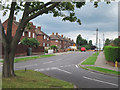
The Avenue
From junction with King George's Drive.
Image: © Oast House Archive
Taken: 8 Aug 2012
0.19 miles
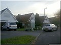
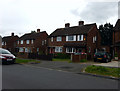
8
The Avenue
The junction at the south end of the Avenue with the start of King George's Drive running across and Kingston Rise opposite.
Image: © Alan Hunt
Taken: 31 Aug 2012
0.21 miles
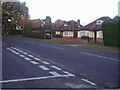
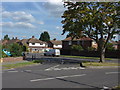
10
King George's Drive, New Haw
Looking east along King George's Drive with the junction of Kingston Rise on the right.
Image: © Alan Hunt
Taken: 10 Aug 2016
0.23 miles