IMAGES TAKEN NEAR TO
Wendley Drive, ADDLESTONE, KT15 3TR
Introduction
This page details the photographs taken nearby to Wendley Drive, KT15 3TR by members of the Geograph project.
The Geograph project started in 2005 with the aim of publishing, organising and preserving representative images for every square kilometre of Great Britain, Ireland and the Isle of Man.

There are currently over 7.5m images from over14,400 individuals and you can help contribute to the project by visiting https://www.geograph.org.uk
Image Map
Images are licensed for reuse under creativecommons.org/licenses/by-sa/2.0
Notes
- Clicking on the map will re-center to the selected point.
- The higher the marker number, the further away the image location is from the centre of the postcode.
Image Listing (17 Images Found)
Images are licensed for reuse under creativecommons.org/licenses/by-sa/2.0
Image
Details
Distance
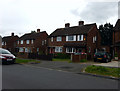
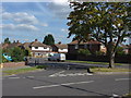
3
The Avenue
From junction with King George's Drive.
Image: © Oast House Archive
Taken: 8 Aug 2012
0.15 miles
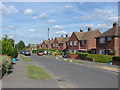
5
The Avenue
The junction at the south end of the Avenue with the start of King George's Drive running across and Kingston Rise opposite.
Image: © Alan Hunt
Taken: 31 Aug 2012
0.18 miles
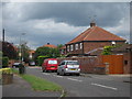
6
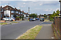
King George's Drive, New Haw
Looking east along King George's Drive with the junction of Kingston Rise on the right.
Image: © Alan Hunt
Taken: 10 Aug 2016
0.20 miles
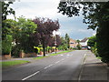
7
Kingston Rise
The eastern arm of Kingston Rise, a road that forms a "U", from the junction with King George's Drive.
Image: © Alan Hunt
Taken: 31 Aug 2012
0.21 miles
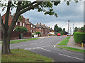
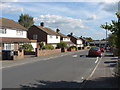
8
Manor Drive
A view along this residential road in New Haw. Most of the houses appear to date from the 1950s.
Image: © Alan Hunt
Taken: 31 Aug 2012
0.21 miles
9
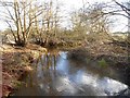
Addlestone Bourne: View from Hall's Farm footbridge (2)
This is the view looking downstream from Image]
Image: © Nigel Cox
Taken: 15 Jan 2016
0.22 miles
10
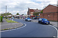
Kingston Rise, New Haw
The one way system at the north end of the Broadway.
Image: © Alan Hunt
Taken: 10 Aug 2016
0.22 miles