IMAGES TAKEN NEAR TO
Woodham Park Road, ADDLESTONE, KT15 3TH
Introduction
This page details the photographs taken nearby to Woodham Park Road, KT15 3TH by members of the Geograph project.
The Geograph project started in 2005 with the aim of publishing, organising and preserving representative images for every square kilometre of Great Britain, Ireland and the Isle of Man.

There are currently over 7.5m images from over14,400 individuals and you can help contribute to the project by visiting https://www.geograph.org.uk
Image Map
Images are licensed for reuse under creativecommons.org/licenses/by-sa/2.0
Notes
- Clicking on the map will re-center to the selected point.
- The higher the marker number, the further away the image location is from the centre of the postcode.
Image Listing (13 Images Found)
Images are licensed for reuse under creativecommons.org/licenses/by-sa/2.0
Image
Details
Distance
1
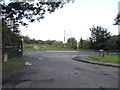
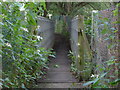
Brox Lane at the junction of Row Town
Brox Lane does not actually go very far, the branch here goes to a nursing home and the rest becomes a footpath shortly after it starts.
Image: © David Howard
Taken: 17 Aug 2014
0.12 miles
2
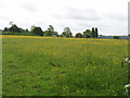
Meadow with buttercups, Hall's Farm, near Woodham
North of Woodham and of the River Bourne, viewed from the road to Rowhill.
Image: © David Hawgood
Taken: 17 May 2006
0.15 miles
3
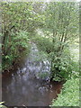
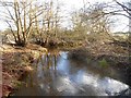
The Bourne, river near Woodham
Photo from the bridge on the road from Rowhill to Woodham
Image: © David Hawgood
Taken: 17 May 2006
0.15 miles
4
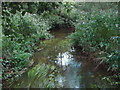
Addlestone Bourne: View from Hall's Farm footbridge (1)
This is the view looking upstream from Image
Image: © Nigel Cox
Taken: 15 Jan 2016
0.17 miles
5
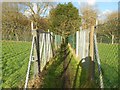
Woodham: Footpath to Row Town / Row Hill
There is some fairly serious fencing here. The photographer is uncertain as to whether it is designed to keep the denizens of the fields in, or the hoi polloi out...
Image: © Nigel Cox
Taken: 15 Jan 2016
0.17 miles
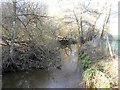
6
River Bourne, Row Town
A view of the Bourne from the footbridge near Hall's Farm. The river marks the boundary between Row Town and Woodham.
Image: © Alan Hunt
Taken: 31 Aug 2012
0.18 miles
7
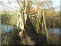
Addlestone Bourne: Hall's Farm Footbridge
This footbridge takes the public footpath linking Woodham and Row Town over the Addlestone Bourne. Please see Image] for a view from several years previously and at a different time of year.
Image: © Nigel Cox
Taken: 15 Jan 2016
0.18 miles
8
River Bourne footbridge
The footbridge over the River Bourne near Hall's Farm.
Image: © Alan Hunt
Taken: 31 Aug 2012
0.18 miles
9
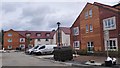
New Care Home Development on Rodwell Farm
Company Info : http://grahamcare.co.uk/the-homes/rodwell-farm/
Image: © James Emmans
Taken: 20 May 2016
0.19 miles
10
Addlestone Bourne: View from Hall's Farm footbridge (2)
This is the view looking downstream from Image]
Image: © Nigel Cox
Taken: 15 Jan 2016
0.19 miles