IMAGES TAKEN NEAR TO
Woodham Park Road, ADDLESTONE, KT15 3TG
Introduction
This page details the photographs taken nearby to Woodham Park Road, KT15 3TG by members of the Geograph project.
The Geograph project started in 2005 with the aim of publishing, organising and preserving representative images for every square kilometre of Great Britain, Ireland and the Isle of Man.

There are currently over 7.5m images from over14,400 individuals and you can help contribute to the project by visiting https://www.geograph.org.uk
Image Map
Images are licensed for reuse under creativecommons.org/licenses/by-sa/2.0
Notes
- Clicking on the map will re-center to the selected point.
- The higher the marker number, the further away the image location is from the centre of the postcode.
Image Listing (4 Images Found)
Images are licensed for reuse under creativecommons.org/licenses/by-sa/2.0
Image
Details
Distance
1
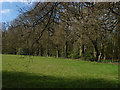
Wood edge, Brox Lane
View of the wood edge near Bourne Rise Farm from Brox Lane
Image: © Alan Hunt
Taken: 20 Apr 2010
0.18 miles
2
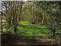
Woods along Brox Lane
View of the woods to the north of Brox Lane near Bourne Rise Farm
Image: © Alan Hunt
Taken: 20 Apr 2010
0.18 miles
3
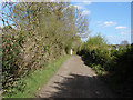
Brox Lane, Row Town
View along brox Lane. the Rose Lane Mobile Home park is on the right of shot.
Image: © Alan Hunt
Taken: 20 Apr 2010
0.23 miles
4
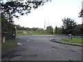
Brox Lane at the junction of Row Town
Brox Lane does not actually go very far, the branch here goes to a nursing home and the rest becomes a footpath shortly after it starts.
Image: © David Howard
Taken: 17 Aug 2014
0.24 miles