IMAGES TAKEN NEAR TO
Woodham Lane, ADDLESTONE, KT15 3PP
Introduction
This page details the photographs taken nearby to Woodham Lane, KT15 3PP by members of the Geograph project.
The Geograph project started in 2005 with the aim of publishing, organising and preserving representative images for every square kilometre of Great Britain, Ireland and the Isle of Man.

There are currently over 7.5m images from over14,400 individuals and you can help contribute to the project by visiting https://www.geograph.org.uk
Image Map
Images are licensed for reuse under creativecommons.org/licenses/by-sa/2.0
Notes
- Clicking on the map will re-center to the selected point.
- The higher the marker number, the further away the image location is from the centre of the postcode.
Image Listing (16 Images Found)
Images are licensed for reuse under creativecommons.org/licenses/by-sa/2.0
Image
Details
Distance
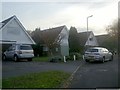
1
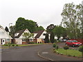
Aprilwood Close, Woodham
Off Woodham Park Road, just north of the B385.
Image: © David Hawgood
Taken: 17 May 2006
0.07 miles
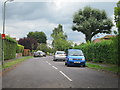
2
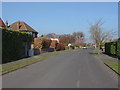
Orchard Way
A view along Orchard Avenue, a suburban street in Woodham.
Image: © Alan Hunt
Taken: 24 Mar 2012
0.09 miles
4
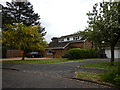
Woodham - Junewood Close Detached House
Image: © James Emmans
Taken: 20 May 2016
0.10 miles
8
Junction of Aprilwood Close and Woodham Park Road
Image: © David Howard
Taken: 31 Oct 2011
0.12 miles
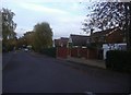
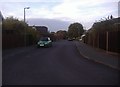
9
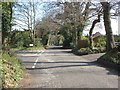
Faris Lane, Woodham
A view along Faris Lane with the junction of Orchard Avenue on the left.
Image: © Alan Hunt
Taken: 24 Mar 2012
0.13 miles
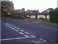
10
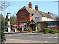
The Victoria public house
A view of the Victoria public house on Woodham Lane from the entrance to the footpath across Anningsley Park.
Image: © Alan Hunt
Taken: 24 Mar 2012
0.13 miles