IMAGES TAKEN NEAR TO
Woodham Lane, ADDLESTONE, KT15 3NN
Introduction
This page details the photographs taken nearby to Woodham Lane, KT15 3NN by members of the Geograph project.
The Geograph project started in 2005 with the aim of publishing, organising and preserving representative images for every square kilometre of Great Britain, Ireland and the Isle of Man.

There are currently over 7.5m images from over14,400 individuals and you can help contribute to the project by visiting https://www.geograph.org.uk
Image Map
Images are licensed for reuse under creativecommons.org/licenses/by-sa/2.0
Notes
- Clicking on the map will re-center to the selected point.
- The higher the marker number, the further away the image location is from the centre of the postcode.
Image Listing (6 Images Found)
Images are licensed for reuse under creativecommons.org/licenses/by-sa/2.0
Image
Details
Distance
2
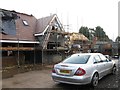
Housing development off Mayfield Avenue
Image: © Alex McGregor
Taken: 18 Feb 2014
0.15 miles
3
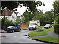
Grange Road, Woodham, with ambulance
An ambulance on an emergency call happened to come along as I was about to take the photo.
Image: © David Hawgood
Taken: 22 May 2006
0.18 miles
4

Ornamental thorn tree (Crataegus) in Woodham
This tree is in Holly Avenue, near Grange Road. At this time of year hedges along many roads are white with hawthorn. This type of pink ornamental thorn is seen frequently in towns. There are several varieties of pink thorn in the Crataegus family.
Image: © David Hawgood
Taken: 22 May 2006
0.18 miles