IMAGES TAKEN NEAR TO
Woodham Lane, ADDLESTONE, KT15 3NA
Introduction
This page details the photographs taken nearby to Woodham Lane, KT15 3NA by members of the Geograph project.
The Geograph project started in 2005 with the aim of publishing, organising and preserving representative images for every square kilometre of Great Britain, Ireland and the Isle of Man.

There are currently over 7.5m images from over14,400 individuals and you can help contribute to the project by visiting https://www.geograph.org.uk
Image Map
Images are licensed for reuse under creativecommons.org/licenses/by-sa/2.0
Notes
- Clicking on the map will re-center to the selected point.
- The higher the marker number, the further away the image location is from the centre of the postcode.
Image Listing (61 Images Found)
Images are licensed for reuse under creativecommons.org/licenses/by-sa/2.0
Image
Details
Distance
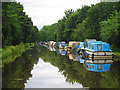
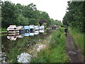
1
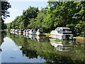
New Haw - River Wey Navigation
A line of pleasure boats moored south of New Haw Lock.
Image: © Colin Smith
Taken: 8 Jul 2022
0.05 miles

4
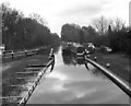
New Haw Lock, Wey Navigation
Looking southwards, the 'turf sided' east side of the lock chamber can be seen. This lock lies at the end of the long straight section which leads past the junction with the Basingstoke Canal.
Image: © Dr Neil Clifton
Taken: 6 Mar 1983
0.06 miles
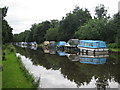
7
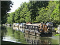
New Haw - River Wey Navigation
Narrowboat "Wey Otter" heading sedately south from New Haw Lock.
Image: © Colin Smith
Taken: 8 Jul 2022
0.07 miles

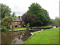
10
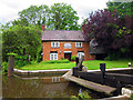
Lock Cottage
Cottage by New Haw Lock on the River Wey Navigation.
Image: © Oast House Archive
Taken: 19 Jul 2012
0.07 miles