IMAGES TAKEN NEAR TO
Byfleet Road, ADDLESTONE, KT15 3JS
Introduction
This page details the photographs taken nearby to Byfleet Road, KT15 3JS by members of the Geograph project.
The Geograph project started in 2005 with the aim of publishing, organising and preserving representative images for every square kilometre of Great Britain, Ireland and the Isle of Man.

There are currently over 7.5m images from over14,400 individuals and you can help contribute to the project by visiting https://www.geograph.org.uk
Image Map
Images are licensed for reuse under creativecommons.org/licenses/by-sa/2.0
Notes
- Clicking on the map will re-center to the selected point.
- The higher the marker number, the further away the image location is from the centre of the postcode.
Image Listing (64 Images Found)
Images are licensed for reuse under creativecommons.org/licenses/by-sa/2.0
Image
Details
Distance
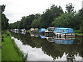
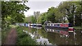
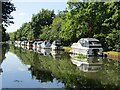
2
Linear moorings above New Haw Lock
Linear moorings are a pain on most canals, because one has lines of boats to cruise slowly past. However, there is no alternative here and the canal is narrow and shallow anyway.
Image: © Graham Horn
Taken: 24 Aug 2008
0.07 miles
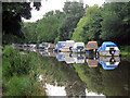
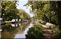
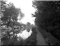
3
River Wey Navigation
Freshly-leaved oaks overhang the canal, with a continuous line of craft moored along the opposite bank.
Image: © Derek Harper
Taken: 10 May 2013
0.08 miles
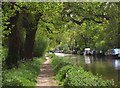
4
Wey Navigation - New Haw
Info : https://en.wikipedia.org/wiki/Wey_and_Godalming_Navigations
The tow path is now part of the E2 European Long Distance Footpath.
Info : https://en.wikipedia.org/wiki/E2_European_long_distance_path
Image: © James Emmans
Taken: 10 May 2016
0.08 miles
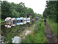
6
Wey Navigation above New Haw Lock
This wide straight stretch has become rather spoiled by excessive linear mooring
Image: © Dr Neil Clifton
Taken: 17 May 1992
0.11 miles
7
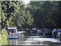
Wey Navigation, New Haw
Straight reach with many moorings for pleasure boats, south of Newhaw Lock.
http://www.weyriver.co.uk/theriver/index.htm
Image: © Colin Smith
Taken: 22 Jul 2012
0.11 miles
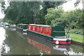
8
New Haw - River Wey Navigation
A line of pleasure boats moored south of New Haw Lock.
Image: © Colin Smith
Taken: 8 Jul 2022
0.12 miles
9
Above New Haw Lock, River Wey Navigation
The navigation was built wide enough here, so it allows for moorings on the offside. Behind the photographer there is (but was not when the picture was taken) the M25 bridge, so in modern times there is a constant roar of traffic here. A bit further back is the junction with the Basingstoke Canal.
Image: © Dr Neil Clifton
Taken: 4 May 1974
0.12 miles