IMAGES TAKEN NEAR TO
Pinewood Grove, ADDLESTONE, KT15 3BU
Introduction
This page details the photographs taken nearby to Pinewood Grove, KT15 3BU by members of the Geograph project.
The Geograph project started in 2005 with the aim of publishing, organising and preserving representative images for every square kilometre of Great Britain, Ireland and the Isle of Man.

There are currently over 7.5m images from over14,400 individuals and you can help contribute to the project by visiting https://www.geograph.org.uk
Image Map
Images are licensed for reuse under creativecommons.org/licenses/by-sa/2.0
Notes
- Clicking on the map will re-center to the selected point.
- The higher the marker number, the further away the image location is from the centre of the postcode.
Image Listing (45 Images Found)
Images are licensed for reuse under creativecommons.org/licenses/by-sa/2.0
Image
Details
Distance
1
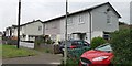
Prefab Housing in Kings Road
Two storey prefab house with concrete panels on ground floor and wooden first floor and unusual metal sheet roof and first floor walls.
Image: © James Emmans
Taken: 19 May 2019
0.12 miles
2
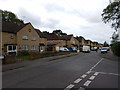
Broomfield Road - New Haw
Junction with Pinewood Grove.
Image: © James Emmans
Taken: 20 May 2016
0.15 miles
3
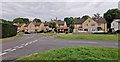
Newhaw - End of Kings Road
Post war housing estate build in various styles and years.
Image: © James Emmans
Taken: 19 May 2019
0.16 miles
4
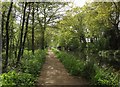
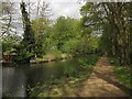
Basingstoke Canal
West of Woodham Bottom Lock, with fresh green leaves on trees overhanging the canal making an attractive scene.
Image: © Derek Harper
Taken: 10 May 2013
0.18 miles
5

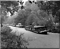
Above Lock No 1, Basingstoke Canal
There are still houseboats there in 2007.
Image: © Dr Neil Clifton
Taken: 14 Oct 2007
0.19 miles
6
Basingstoke Canal near New Haw
From the same spot as Image], looking in the opposite direction.
Image: © Derek Harper
Taken: 10 May 2013
0.19 miles
7
Derelict houseboats above Lock No 1, Basingstoke Canal
Some of the houseboats had been abandoned in derelict condition and their owners could not be traced
Image: © Dr Neil Clifton
Taken: 16 Oct 1988
0.19 miles
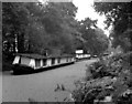
8
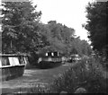
Houseboats on the Basingstoke Canal
Before the Basingstoke Canal could be restored for through navigation, houseboats which had been moored for many years in the Woodham lock flight had to be removed. Here some of the boats are seen in the pound above Lock No 1
Image: © Dr Neil Clifton
Taken: 25 Aug 1980
0.19 miles
9
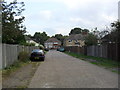
Woodham
An access road between Lindsay Road and Scotland Bridge Road.
Image: © Burgess Von Thunen
Taken: 13 Oct 2011
0.19 miles
10
Derelict houseboats above Lock No 1
See Image
Image: © Dr Neil Clifton
Taken: 16 Oct 1988
0.19 miles