IMAGES TAKEN NEAR TO
Park Close, ADDLESTONE, KT15 3AL
Introduction
This page details the photographs taken nearby to Park Close, KT15 3AL by members of the Geograph project.
The Geograph project started in 2005 with the aim of publishing, organising and preserving representative images for every square kilometre of Great Britain, Ireland and the Isle of Man.

There are currently over 7.5m images from over14,400 individuals and you can help contribute to the project by visiting https://www.geograph.org.uk
Image Map
Images are licensed for reuse under creativecommons.org/licenses/by-sa/2.0
Notes
- Clicking on the map will re-center to the selected point.
- The higher the marker number, the further away the image location is from the centre of the postcode.
Image Listing (31 Images Found)
Images are licensed for reuse under creativecommons.org/licenses/by-sa/2.0
Image
Details
Distance
1
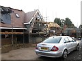
Housing development off Mayfield Avenue
Image: © Alex McGregor
Taken: 18 Feb 2014
0.11 miles
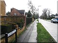
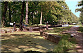
3
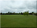
New Haw Park
Southern boundary is the Basingstoke Canal
Image: © James Emmans
Taken: 20 May 2016
0.18 miles
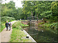
4
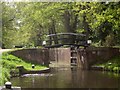
Woodham Bottom Lock, Basingstoke Canal
Image: © Derek Harper
Taken: 10 May 2013
0.20 miles
5
Woodham Bottom Lock, Basingstoke Canal
Being the easternmost lock on the canal before its junction with the Wey Navigation.
Image: © Derek Harper
Taken: 10 May 2013
0.20 miles
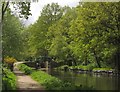
6
Basingstoke Canal
The canal east of Woodham Bottom Lock No 1.
Image: © Derek Harper
Taken: 10 May 2013
0.20 miles
7
Woodham Bottom Lock No 1, Basingstoke Canal
Image: © Dr Neil Clifton
Taken: 17 May 1992
0.21 miles
8
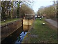
Woodham Bottom Lock
The final set of lock gates on the Basingstoke Canal before it reaches the River Wey Navigation.
Image: © Alan Hunt
Taken: 4 Mar 2013
0.21 miles
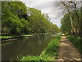
9
Bottom Lock, Basingstoke Canal
About 450 m up from the junction with the River Wey Navigation.
Image: © Robin Webster
Taken: 13 Sep 2015
0.21 miles
10
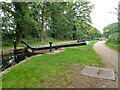
Bottom Lock, Basingstoke Canal
About 450 m up from the junction with the River Wey Navigation.
Image: © Robin Webster
Taken: 13 Sep 2015
0.21 miles